0345 33 11 080
CoachBookings Logo
Bookings for this holiday are now closed
You are here: Home » Coastal Breaks » Blackpool Illuminations

Blackpool Illuminations

Destination: BlackpoolOperator: Grand UK Holidays Terms
Departs: 25/10/2010Type: Coastal Breaks
Duration: 5 daysQuality: Good * * *
Departs Via: South EastBoard: Half Board
Tour Code: D7818Transport: Coach Pickup
Adults £279.00
Deposit Per Person Payment required in full
* Children: Not allowed
* Babies: Not allowed
Sorry, there's not enough time left to book you on this trip!
Description
For decades, the famous Blackpool Illuminations have been drawing crowds from all over the world, eager to see the greatest free show on earth! For two whole months Blackpool seafront and the splendid Tower are transformed into a magical, fairytale world of glorious light and colour interspersed with impressive storytelling tableaux. This magnificent display features nearly 400,000 bulbs, hundreds of illuminated figures and themes and fifty miles of festoon strip. All this, combined with a well situated, comfortable hotel, good food and hospitality - and the chance to visit the lovely Lake District - make our breaks to Blackpool Illuminations an unforgettable holiday experience.
Itinerary
Full Day
Within an hour we are amid some of the most beautiful scenery on our full day tour of the Lake District. We drive to Newby Bridge, at the southern-most tip of Lake Windermere, where there is an opportunity to take a lake cruise. Moving on we follow Windermere’s wooded banks to Bowness and then continue with a memorable drive over the Kirkstone Pass to Patterdale. Half Day
An extended half day tour to the elegant resort of Southport, with its beautifully laid out gardens and famous Lord Street - one of the finest thoroughfares in the north of England. Evening Tour
An evening drive along the spectacular 'Illuminations' seafront.
Venue Information
THE WARWICK HOTEL enjoys a prime seafront position on the quieter, completely level New South Promenade - convenient for the Pleasure Beach and Sandcastle, and just opposite one of the many tram stops. Here you can enjoy a swim in our heated indoor swimming pool, and look forward to good food and friendly service in our spacious restaurant. There are two bars, regular evening entertainment and comfortable lounge areas. All bedrooms feature private facilities, television and tea and coffee making facilities. • Full breakfast and four course evening dinner plus tea or coffee • Two nights entertainment • Lift
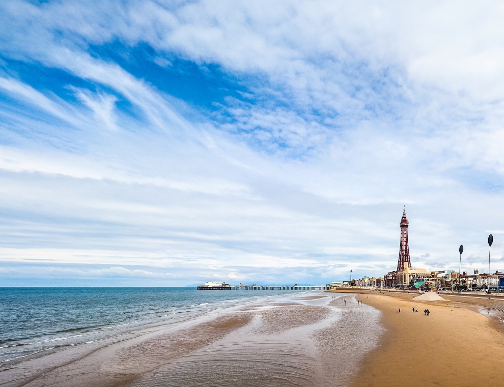
Picture: Click to ViewPicture: Click to ViewPicture: Click to ViewPicture: Click to View
Pick-Up Points
.Abingdon Opposite The War Memorial Map
.Acle The Kings Head Public House Map
.Acton Outside West London Trade Union Club Map
.Addlestone Bus Stop Outside Tesco Map
.Aldershot Bus Stop Outside Princes Hall Map
.Ampthill Opp Prince Wales PH Map
.Andover Outside Whitehart Hotel Map
.Ashford Bus Stop A Map
.Attleborough Outside HSBC Bank Map
.Aylesbury Bus Station Map
.Aylsham Bus Stop Map
.Bagshot Outside Vickery & Co Estate Agents Map
.Baisingstoke Bus Layby Outside Sainsburys Map
.Baldock Clare House Map
.Banbury Cross Taxi Rank Map
.Banstead Outside Ora Hair Salon Map
.Barking Bus Stop A Map
.Barnet Outside Everyman Cinema (previously ODEON Cinema) Map
.Basildon Coach Stop Outside Trafford House Map
.Beaconsfield Bus Layby Outside Waitrose Map
.Beckenham Bus Stop R Near War Memorial Map
.Bedford Bus Station, Bay 12 Map
.Bedworth Opposite Iceland Map
.Bethnal Green Outside Apple Travel Map
.Bexhill Town Hall Map
.Bexley Almshouses Map
.Bexleyheath Outside Library Map
.Bicester Bus Station, Next To Tesco Map
.Billericay Bus Stop Opposite Burghstead Close Map
.Birchington Opposite The Three Legged Toad Map
.Bishops Stortford Bus Interchange Map
.Blackheath Bus Stop Map
.Bletchley Bus Station Map
.Bognor Regis Outside Railway Station Map
.Borehamwood Outside The Fire Station Map
.Borough Green Railway Station Map
.Boscombe Sovereign Centre Map
.Boston Main Bus Station Map
.Bourne The Bus Station Map
.Bournemouth The Travel Interchange, By Railway Station Map
.Bracknell Bus Station Bay 3 Map
.Braintee Bus Stop Outside Tesco Map
.Braintree Bus Stop Outside Job Centre Map
.Brandon Bus Stop Outside Tesco Map
.Brentford Opposite Police Station Map
.Brentwood Bus Stop Near KFC Map
.Brightlingsea St James Church Map
.Brighton Bay 6 - Bus Station Map
.Broadstairs Piermont Hall Map
.Bromley Behind Churchill Insurance Court Map
.Buckingham Hospital Entrance Map
.Bungay Coach Stop Map
.Burgess Hill Outside Sussex House Map
.Bury St Edmunds Bus Station Map
.Camberley Opposite Railway Station Map
.Cambridge Coach Lay By Map
.Canterbury Bus Layby Pin Hill Map
.Canvey Island Bus Stop Opposite Sainsbury Map
.Carshalton Bus Stop Map
.Caterham Outside Llyods Opposite Railway Station Map
.Catford Bus Stop Outside Catford Bridge Tavern Map
.Chadwell Heath Outside Police Station Map
.Chalfont St Peter Car Park Map
.Chatham Railway Station Map
.Chatteris Outside Police Station Map
.Cheam Bus Stop Opposite Sainsburys Map
.Chelmsford Holiday Coach Stop Map
.Chesham Bus Stop Opposite Nationwide Building Society Map
.Cheshunt Outside Llyods Bank Map
.Chichester Outside Foundry Public House Map
.Chigwell Outside Chigwell Tube Station Map
.Chingford Outside Rail Station Map
.Chipping Ongar Opposite Library Map
.Christchurch Bus Stop Map
.Clacton-on-Sea Outside Railway Station Map
.Cliftonville Outside Roma Pizza Map
.Cobham Bus Stop Outside Waitrose Map
.Coggeshall Bus Stop Chapel Inn Map
.Colchester Bus Station Map
.Corby Bus Stop 7, Near Church Map
.Corringham Bus Stop By Station House Map
.Coulsdon Outside Sentinal House Map
.Coventry Outside Britannia Hotel Map
.Crawley Stand E, Bus Station Map
.Cromer Bus Station Map
.Crowborough Bus Lay By Map
.Croydon Outside Fairfields Halls Map
.Crystal Parade Outside Petrol Station Map
.Dagenham Outside Morrisons Map
.Dartford Outside Library Map
.Daventry Bus Station Map
.Deal Bus Stop Map
.Dereham Barclays Bank Map
.Didcot Outside Video Shop Map
.Diss Bus Station Map
.Dorking Outside White Horse Hotel Map
.Dover Bus Stop A Map
.Dovercourt Railway Station Map
.Dunstable Saracens Head Public House Map
.Ealing Bus Stop N, Outside Xanadu Hotel Map
.East Grinstead Opposite Llyods TSB Bank Map
.Eastleigh Bus Station Map
.Edgware Layby Opposite The Halifax Map
.Edmonton Opposite Police Station Map
.Egham Bus Layby Map
.Eltham Outside Boots Map
.Ely Barton Road Car Park Map
.Enfield New River House Map
.Epping Opposite Barclays Bank Map
.Epsom Bus Stop Outside Railway Station Map
.Ewell Bus Stop Opposite Bourne Hall Map
.Fakenham Coach Park Map
.Fareham Outside British Heart Foundation Map
.Farnham Opposite Bishops Table Hotel Map
.Faversham Bus Stop Map
.Felixstowe Great Eastern Square Map
.Folkestone Bus Stop, Bouverie Road West Map
.Friern Barnet Outside Sophia Maria Hairdressers Map
.Frinton On Sea Bus Stop Adjacent To Railway Station Map
.Gidea Park Bus Stop Layby Railway Station Map
.Gillingham Outside Bus Station Map
.Glenfield Bus Stop Map
.Godalming Bus Layby Outside Sainsburys Garage Map
.Gorleston The Library Map
.Gosport Bus Station Coach Bay Map
.Grantham Bus Station Map
.Gravesend Bus Stop Y Map
.Grays The Oak Public House Map
.Great Dunmow Bus Stop Opposite Post Office Map
.Great Wakering Bus Stop Red Lion Public House Map
.Great Yarmouth Bus Layby Map
.Greenford Opposite Police Station Map
.Guildford Guildford Railway Station, Bus Stop G Map
.Hadleigh Bus Station Map
.Hadleigh Hadleigh Church Bus Stop Map
.Halesworth GPO Sorting Office Map
.Halisham Bus Layby Map
.Halstead Opposite Greggs Map
.Harlow Bus Station, Near Taxi Rank Map
.Harold Hill Opposite Swimming Pool Map
.Harold Wood Bus Stop C, Opposite Railway Station Map
.Harpenden Opposite Barclays Bank Map
.Harrow On The Hill Outside The Safari Cinema Map
.Hastings Bus Stop Near WC Map
.Hatfield Express Bus Stop Map
.Havant Layby Outside Mcdonalds Map
.Haverhill Bus Station Map
.Hawkhurst British Legion Bus Stop Map
.Hayes Outside Bingo Hall Map
.Heacham Outside Mill Lavender Centre Map
.Hemel Hempstead Outside Bus Station Map
.Henley On Thames Bus Stop Outside Bonus Print Map
.Herne Bay Bus Stop Outside Library Map
.Hertford The Dog & Whistle Map
.Heston Granada Services Westbound Coach Park Map
.Hethersett B1172 Bus Stop Map
.High Wycombe Railway Station Map
.Highcliffe Sea Corner Opposite Police Station Map
.Hinckley Bus Station Map
.Hitchin Opposite Queen Street Car Park Map
.Hoddesdon Clock Tower Map
.Holbeach Opposite Library Map
.Holland On Sea The Roaring Donkey Map
.Holt War Memorial Map
.Horley Outside Railway Station Map
.Hornchurch Outside Library Map
.Horndean Bus Stop Layby Outside The Precinct Map
.Horsham Outside Railway Station Map
.Hounslow Hounslow West Tube Station Map
.Hove Bus Stop Outside The Station Public House Map
.Huntington Mill Common Bus Station Map
.Hythe Bus Layby Map
.Ilford Outside Ladbrookes Map
.Ingatestone Outside Bell PH Map
.Ipswich Railway Station Map
.Kenilworth Kenilworth Map
.Kettering Bay 2 Outside Library Map
.Kidlington Outside Black Horse Public House Map
.Kings Langley Opposite Rose & Crown Public House Map
.Kingston Upon Thames Outside Blue Hawaii Map
.Lakenheath Outside Library Map
.Lancing Bus Stop Opposite Beach Green Map
.Larkfield Bus Stop Outside The Wealden Hall Restaurant Map
.Leatherhead Southside Bus Stop Map
.Leicester Opposite Sainsburys Map
.Leigh On Sea Outside The Elms Public House Map
.Leighton Buzzard Bus Stop Outside Halifax Map
.Leiston Old Engineer Arms Map
.Lewisham Bus Stop Junction Off Map
.Leyton Bus Stop Outside Tesco Map
.Littlehampton Anchor Springs Map
.Long Stratton Budgens, By Head Stone Garage Map
.Long Sutton Telephone Kiosk Map
.Loughton Bus Stop Outside Homebase Map
.Luton Railway Station Entrance Map
.Maidenhead Bus Stop Map
.Maidstone Bus Stop Map
.Maldon All Saints Church Map
.Manningtree Outside Skinners Arms Map
.March Opposite Nationwide Building Society Map
.Margate Bus Stop D Clock Tower Map
.Market Deeping Barclays Bank Map
.Market Harborough Bus Station, Market Hall Map
.Mildenhall Bus Station Map
.Mill Hill Bustop Outside Sacred Heart Church Map
.Milton Keynes Central Bus Station Map
.Morden Bus Layby Outside The China Garden Map
.New Malden Corner Of Malden Road Map
.New Milton Outside Bradbeers Store Map
.Newbury Bus Layby Outside Newbury Train Station Map
.Newhaven Denton Corner Bus Stop Map
.Newmarket Bus Stop Palmers Map
.Newport Pagnell Outside Boots Map
.Newprt Pagnell Services Northbound Lorry Park M1 Map
.Northampton Upper Mounts Car Park Map
.Northholt Bus Stop Outside Post Office Map
.Norwich Bus Layby John Lewis Map
.Nuneaton Town Centre Bus Station Map
.Oadby Outside Co-op Travel Map
.Oakham Market Place Map
.Orpington Bus Stop Map
.Oxford Layby Outside Playhouse Theatre Beaumont Street Map
.Oxted Bus Layby Outside Council Offices Map
.Peacehaven Meridian Centre Map
.Peterborough Bay 19/20 Bus Station Map
.Petersfield Bus Stop Next To Cafe Map
.Plaistow Bus Stop Outside Greengate Public House Map
.Polegate Bus Stop Outside St George Church Map
.Poole National Express Bus Stop Station Map
.Portslade Bus Stop Outside Railway Station Map
.Portsmouth The Hard Bus Station Map
.Potters Bar Outside Senate House Map
.Rainham Outside Cricketers PH Map
.Ramsgate Harbour Parade Map
.Rayleigh Bus Lay By Crown Public House Map
.Reading Chieveley Services, Map
.Reading Railway Station,Below Clock Map
.Redbridge Outside Tube Station Map
.Redhill Outside Prezzos Restaurant, Opposite Sainsburys Map
.Reigate The Bell Bus Stop, Bus Stop Q Map
.Ringwood Meeting House Lane Map
.Rochester Bus Stop Outside Rochester Community Hub Map
.Romford Bus Stop H Map
.Romsey Bus Station, Behind Aldi Map
.Royal Leamington Spa Opposite McDonalds Map
.Rugby Clock Tower Map
.Ruislip Railway Station Forecourt Map
.Rushden Outside Orbitt Tyres Map
.Rustington Outside Tesco Express Map
.Rye Rail Station Map
.Saffron Walden Outside Temeraire Public House Map
.Saltdean Bus Layby Map
.Sandwich Guildhall Map
.Sandy Bus Stop Market Square Map
.Sawbridgeworth Outside Budgens Bus Stop Map
.Seaford Layby Opposite Flowers Furniture Station Approach Map
.Sevenoaks Bus Terminus, Entrance Off High Street Map
.Sheerness Bus Stop Outside Bus Station Map
.Shepperton Bus Stop Opposite The Bakers Map
.Sheringham Bus Stop Map
.Shoeburyness Bus Stop Inside Asda Map
.Shoreham By Sea Bus Layby Map
.Sidcup Iceland Map
.Sittingbourne Railway Station Map
.Slough Bus Station Bay 12 Map
.Soham Outside Re Lion Public House Map
.South Benfleet Coach Stop, Saddlers Farm Roundabout Map
.South Mimms M25/A1M Services Coach Park Map
.South Ockendon Outside Knight Of Aveley PH Map
.Southampton National Express Coach Station Map
.Southchurch Outside White Horse Map
.Southend Victoria Circus Bus Stop Map
.Spalding Bus Station Map
.St Aines Bay 10 Bus Station Map
.St Albans City Railway Station Map
.St Ives Bus Station Map
.St Leonards Victoria Statue Map
.St Neots Market Square Map
.Stamford Bus Station Map
.Stanford - Le- Hope Claridon House Map
.Stanmore Bus Layby O/S AA Building Map
.Stansted Mountfitchet Outside Feathers Public House Map
.Staple Hurst The Railway Station Map
.Stevenage Outside Matalan Map
.Stowmarket Outside The Railway Station Map
.Stratford National Express Bus Station Map
.Streatham Outside United Reformed Church Map
.Strood Civic Centre Map
.Sudbury Bus Station Map
.Sudbury Wickham Market Square Opposite Chemist Map
.Surbiton Bus Stop By Rail Bridge Map
.Sutton Securicor Buildings Opposite Police Station Map
.Swaffham Outside Sue's News Shop Map
.Swanley Bus Stop Back Of Asda Map
.Tenterden The Steam Railway Station Map
.Thame Bus Layby Outside Town Hall Map
.Thatcham Bus Stop, Outside McColls Store Map
.Thetford Minstergate Bus Station Map
.Thorpe Bay Railway Station Map
.Thurrock Moto Services Coach Park Map
.Tonbridge Bus Layby Map
.Tring Bus Stop Outside Rose & Crown Hotel Map
.Tunbridge Wells Opposite The Assembly Halls Map
.Twickenham Cheltenham & Gloucestor Building Society Map
.Uckfield Bus Station Map
.Upminster Focus Do It All Map
.Uxbridge Opposite Allied Irish Bank Map
.Waltham Abbey Outside Abbey Taverna Map
.Walthamstow HSBC Map
.Walton On Thames Outside Railway Station Map
.Walton On The Naze Rail Station Coach Park Map
.Warboys Clock Tower Map
.Ware Bus Stop Opposite Greggs Bakers Map
.Warwick National Express Bus Stop Map
.Waterlooville Bu Stop Opposite St Georges Church Map
.Watford Opposite White Lion Public House Map
.Wellingborough Bus Stop Map
.Welwyn Hunters Bridge Map
.West Wickham Outside Boots Map
.Westcliff Palace Theatre Map
.Westgate On Sea Coach Stop Railway Station Map
.Whetstone Bus Stop Opposite Nat West Bank Map
.Whistable Harbour Street Bus Stop Map
.Whittlesey The Market Place Map
.Wickford Outside Fraiers Map
.Wigston Bus Stop Map
.Wimbledon Wimbledon Theatre Map
.Wimborne Minister Bus Stop Outside HSBC Map
.Winchester King Alfred Statue Map
.Windsor Windsor Coach Park Map
.Wisbech Horsefair Coach Stop Map
.Witham Lloyds The Chemist Map
.Woking Bay 1-3 The Broadway Map
.Wokingham Bus Layby Map
.Wood Green Bus Garage Opposite Tube Station Map
.Woolwich Bus Stop Map
.Worthing Outside Central Railway Station Map
.Wymondham Bus Stop Map
Click the compass icons to preview pickups.
↑ Return to Top - Contact Us - F.A.Q. - Coach Operators - Group Bookings - Hotels - Attractions - Sitemap - Home