0345 33 11 080
CoachBookings Logo
Bookings for this holiday are now closed
You are here: Home » Sight Seeing » Cream of the Cotswolds

Cream of the Cotswolds

Destination: CotswoldsOperator: Grand UK Holidays Terms
Departs: 09/10/2023Type: Sight Seeing
Duration: 5 daysQuality: Good * * *
Departs Via: All AreasBoard: Half Board
Tour Code: D37361Transport: Coach Pickup
Adults £559.00
Deposit Per Person £65.00
* Children: Not allowed
* Babies: Not allowed
Sorry! This trip has sold out.
Description
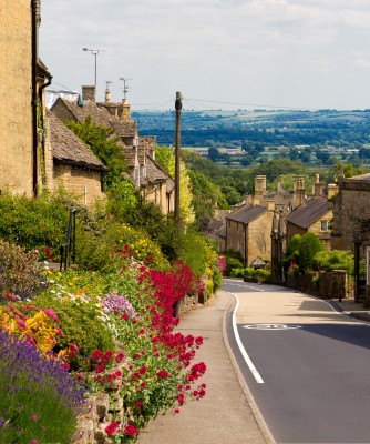
Highlights: Bourton-on-the-Water, Stow-on-the-Wold, Cirencester, Chavenage House, Ride on the Gloucestershire & Warwickshire Railway, Moreton-in-Marsh
Explore some of England’s most treasured landscapes, where mellow stone-built towns and villages are tucked away amidst rolling limestone hills. The Cotswolds became prosperous with the medieval wool trade, when many fine churches and manor houses were built and left unspoilt to this day. It’s an area of outstanding natural beauty and our holiday base, Cheltenham, is one of our finest historic treasures and the most complete Regency town in Britain.
Itinerary
Excursions

FULL DAY: Today we head into the lush meadows and honey coloured stone villages of the Cotswolds where this wonderful scenic tour takes in some of the most perfect picture-postcard villages of middle England. First to Moreton-in-Marsh where there is an opportunity to explore the huge Tuesday market, a celebrated weekly event, which takes over the High Street. We then arrive at Stow-on-the-Wold, where there is time to explore the ancient market square surrounded by dozens of independent antique shops. We conclude the day in Bourton-on-the-Water, a renowned Cotswold village with the little River Windrush flowing beneath tiny humpback bridges.

FULL DAY: All aboard today for a ride on the Gloucestershire & Warwickshire Railway as it steams serenely through the rolling Cotswold Hills to Broadway, a delightful place often referred to as the ‘Jewel of the Cotswolds’. Here there is time to explore the ‘broad way’ with its ancient Cotswold stone cottages and myriad of antique shops before returning through the orchards of the Vale of Evesham.

FULL DAY: Heading south today, we reach Cirencester, often referred to as the ‘Capital of the Cotswolds’, before we make our way this afternoon to Chavenage House, a 400 year old Cotswold Manor where the Lowsley-Williams family take pride in welcoming you personally to their home.

Everything Included:

- Free local joining points
- Collect Coach Miles
- All coach travel
- Reserved seats on tour coaches
- Tour Manager escorted
- Hotel accommodation and board as stated
- No single room supplement
- Excursions/itinerary as stated
- Admission fees and entertainment if stated
- Complete luggage handling
- Price-Back Insurance Offer


Pick-up Arrangements
01603 886767
For details on your pick up arrangements please click here.
Venue Information
Cheltenham Chase Hotel Cheltenham
Surrounded by countryside with spectacular views across the Cotswolds, this modern, luxurious hotel offers the perfect location for touring into the Cotswold scenery.

★★★★ (AA)
- Restaurant, lounge bar
- En-suite bedrooms
- Free Wi-Fi
- Indoor swimming pool, gym, sauna, spa
- Full buffet breakfast and three course evening dinner plus tea or coffee
- Lift
Hotel/Attraction Links
Picture: Click to ViewPicture: Click to ViewPicture: Click to View
Pick-Up Points
.Abingdon Opposite The War Memorial Map
.Acle The Kings Head Public House Map
.Acton Outside West London Trade Union Club Map
.Addlestone Bus Stop Outside Tesco Map
.Aldershot Bus Stop Outside Princes Hall Map
.Ashford Bus Stop A Map
.Attleborough Outside HSBC Bank Map
.Aylesbury Bus Station Map
.Aylsham Bus Stop Map
.Baldock Clare House Map
.Banbury Bus Stop Outside Whately Hall Hotel Map
.Banstead Outside Ora Hair Salon Map
.Barnet Outside Everyman Cinema (previously ODEON Cinema) Map
.Basildon Coach Stop Outside Trafford House Map
.Beaconsfield Bus Layby Outside Waitrose Map
.Beccles Old Market Place Map
.Beckenham High Street/ Kelsey Square Bus Stop By HSBC Map
.Bedford Bus Stop R1, Outside Bedford Train Station Map
.Bexley Almshouses Map
.Bexleyheath Outside Library Map
.Bicester Outside JB Barbers Map
.Biggleswade Bus Station Map
.Billericay Bus Stop Opposite Burghstead Close Map
.Birchington Bus Stop Opposite Lloyds Bank Map
.Blackheath Bus Stop Map
.Bletchley Bus Station Map
.Borehamwood Outside The Fire Station Map
.Bourne The Bus Station Map
.Bracknell Bus Station Bay 3 Map
.Braintree Bus Stop Outside Job Centre Map
.Brandon Bus Stop Outside Tesco Map
.Brentwood Bus Layby Warley Hill Map
.Brightlingsea St James Church Map
.Brighton Bus Stop Z Map
.Broadstairs Piermont Hall Map
.Bromley Outside Bromley South Railway Station Map
.Buckingham Hospital Entrance Map
.Burgess Hill Outside Sussex House Map
.Bury St Edmunds Bus Station Map
.Camberley Opposite Railway Station Map
.Cambridge Coach Bay Opposite The Arundal House Hotel Map
.Canterbury Coach Stop Opposite Snooker Club Map
.Canvey Island Bus Stop Opposite Sainsbury Map
.Carshalton Bus Stop Map
.Caterham Outside Llyods Opposite Railway Station Map
.Chadwell Heath Outside Police Station Map
.Chalfont St Peter Car Park Map
.Chatham Railway Station Map
.Chelmsford Holiday Coach Stop Map
.Chesham Bus Stop Opposite Nationwide Building Society Map
.Cheshunt Outside Llyods Bank Map
.Chichester Outside Foundry Public House Map
.Chingford Outside Rail Station Map
.Chipping Ongar Opposite Library Map
.Clacton-on-Sea Outside Railway Station Map
.Cobham Bus Stop Outside Waitrose Map
.Cobham Cobham Services, Services Information Point Map
.Colchester Bus Stop Outside Colchester Rail Station Map
.Collier Row Outside KFC Map
.Corby Bus Stop 7, Near Church Map
.Corringham Bus Stop By Station House Map
.Coventry Outside Britannia Hotel Map
.Crawley Outside Crawley Railway Station Map
.Crowborough The Cross Bus Stop Map
.Croydon Bus Stop Outside Library Map
.Dagenham Outside Morrisons Map
.Dartford Outside Library Map
.Daventry Bus Station Map
.Deal Bus Stop Map
.Dereham Bus Stop Outside Texco Extra Map
.Didcot Bus Stop Outside Subway Map
.Diss Bus Station Map
.Dorking Outside White Horse Hotel Map
.Dover Bus Stop A Map
.Dovercourt Railway Station Map
.Downham Market Bus Stop Map
.Dunstable Saracens Head Public House Map
.Ealing Bus Stop N, Outside Xanadu Hotel Map
.East Grinstead Opposite Llyods TSB Bank Map
.Eastbourne Outside Pier Entrance Map
.Eastleigh Bus Station Map
.Eltham Outside Boots Map
.Ely Barton Road Car Park Map
.Enfield Bus Stop N, Outside Labrookes Map
.Epping Opposite Barclays Bank Map
.Epsom Bus Stop B, Opposite Clock Tower Map
.Ewell Bus Stop Opposite Bourne Hall Map
.Fakenham Bus Stop Near Salvation Army Map
.Fareham Outside British Heart Foundation Map
.Farnham Opposite Bishops Table Hotel Map
.Flitwick Bus Stop Outside Top Gear Map
.Folkestone Bus Stop, Bouverie Road West Map
.Gillingham Outside Bus Station Map
.Godalming Bus Layby Outside Sainsburys Garage Map
.Gorleston The Library Map
.Gravesend Bus Stop Y Map
.Grays The Oak Public House Map
.Great Dunmow Bus Stop Opposite Dunmow Club Map
.Great Yarmouth Bus Layby Map
.Guildford Guildford Railway Station, Bus Stop G Map
.Hadleigh Bus Station Map
.Hadleigh St James The Less Church Bus Stop Map
.Hailsham Bus Layby Outside Police Station Map
.Halstead Opposite Greggs Map
.Harlow Bus Station, Near Taxi Rank Map
.Harold Wood Bus Stop C, Opposite Railway Station Map
.Harpenden Opposite Barclays Bank Map
.Harrow On The Hill Outside Sakonis Restaurant Map
.Hastings Bus Stop Near WC Map
.Hatfield Express Bus Stop Map
.Hatfield Express Bus Stop Outside Hatfield Train Station Map
.Havant The Bus Station Map
.Haverhill Bus Station Map
.Hayes Outside Bingo Hall Map
.Haywards Heath Opposite Claire Hall Map
.Hemel Hempstead Bus Stop M Map
.Herne Bay Bus Stop Outside Library Map
.Hertford The Dog & Whistle Map
.High Wycombe Outside Rail Station Map
.Hitchin Opposite Queen Street Car Park Map
.Hoddesdon Clock Tower Map
.Holbeach Opposite Library Map
.Horley Outside Railway Station Map
.Hornchurch Bus Stop D, Opposite Sainsbury's Car Park Map
.Horsham Outside Railway Station Map
.Hounslow Hounslow West Tube Station Map
.Hove Bus Stop Outside The Station Public House Map
.Hythe Bus Layby Map
.Ilford Outside Ladbrookes Map
.Ingatestone Outside Bell PH Map
.Ipswich Railway Station Map
.Kettering Coach Bay Map
.Kidlington Outside Black Horse Public House Map
.Kings Langley Opposite Rose & Crown Public House Map
.Kings Lynn Bus Station, Stand H Map
.Larkfield Bus Stop Outside The Wealden Hall Restaurant Map
.Leatherhead Southside Bus Stop Map
.Leicester Bus Stand PC, St Nicholas Circle Map
.Leighton Buzzard Bus Stop Outside Halifax Map
.Letchworth Bus Stop D Map
.Long Stratton Outside Barclays Bank Map
.Long Sutton Telephone Kiosk Map
.Loughton Bus Stop Outside Homebase Map
.Lowestoft Bus Stop Outside Railway Station Map
.Luton Railway Station Entrance Map
.Maidenhead Bus Stop Map
.Maidstone Bus Stop Outside West Rail Station Map
.Maldon All Saints Church Map
.Manningtree Outside Skinners Arms Map
.March Opposite Nationwide Building Society Map
.Margate Bus Stop D Clock Tower Map
.Market Harborough Bus Station, Market Hall Map
.Mildenhall Bus Station Map
.Milton Keynes Bus Stop Z6 Map
.Morden Bus Layby Outside The China Garden Map
.New Malden Corner Of Malden Road Map
.Newmarket Outside Hughes Electrical Store Map
.Newport Pagnell Outside Boots Map
.North Walsham Bus Stop Map
.Northampton Coach Park Opposite Police Station Map
.Northampton The Coach Park, Northampton Services Map
.Norwich Bus Layby John Lewis Map
.Orpington Bus Stop Map
.Oxford Layby Outside Playhouse Theatre Beaumont Street Map
.Oxted Bus Layby Outside Council Offices Map
.Peterborough Acland Street Coach Park Map
.Polegate Bus Stop Outside St George Church Map
.Portslade Bus Stop Outside Railway Station Map
.Portsmouth Coach Bay, Opposite George Public House Map
.Potters Bar Bus Stop Opposite Highview Gardens Map
.Rainham Outside Cricketers PH Map
.Ramsgate Harbour Parade Map
.Rayleigh Bus Lay By Crown Public House Map
.Reading Bus Layby Greyfriars Road Map
.Reading Reading Services Map
.Redbridge Outside Tube Station Map
.Redhill Outside Prezzos Restaurant, Opposite Sainsburys Map
.Reigate The Bell Bus Stop, Bus Stop Q Map
.Rickmansworth Layby Outside Railway Station Map
.Romford Bus Stop H Map
.Royston Bus Layby Outside Bus Station Map
.Rugby Clock Tower Map
.Ruislip Ruislip Underground Station Forecourt Map
.Rushden Outside Orbitt Tyres Map
.Rustington Outside Tesco Express Map
.Saffron Walden Outside Temeraire Public House Map
.Sandwich Guildhall Map
.Sandy Bus Stop Market Square Map
.Saxmundham Outside Sorting Office Map
.Seaford Layby Opposite Flowers Furniture Station Approach Map
.Sevenoaks Bus Terminus, Entrance Off High Street Map
.Shepperton Bus Stop Opposite The Bakers Map
.Shoeburyness Bus Stop Inside Asda Map
.Sidcup Iceland Map
.Sittingbourne Railway Station Map
.Slough Bus Stop B, Outside Bus Station Map
.South Benfleet Coach Stop, Saddlers Farm Roundabout Map
.South Mimms Coach Park Entrance Map
.Southampton National Express Coach Station Map
.Southend Victoria Circus Bus Stop Map
.Spalding Bus Station Map
.St Albans Coach Bay D City Rail Station Map
.St Ives Bus Station Map
.St Neots Market Square Map
.Staines Bus Stop Outside Staines Railway Station Map
.Stamford Bus Station Map
.Stevenage Outside Matalan Map
.Stowmarket Outside The Railway Station Map
.Stratford Bus Stop N, Outside Travelodge Map
.Streatham Outside United Reformed Church Map
.Strood Bus Stop By Prince Of Wales Map
.Sudbury Bus Station Map
.Surbiton Bus Stop By Rail Bridge Map
.Sutton Opposite Police Station Map
.Swaffham Outside Sue's News Shop Map
.Swanley Bus Stop Back Of Asda Map
.Thame Bus Layby Outside Town Hall Map
.Thetford Minstergate Bus Station Map
.Thorpe Bay Railway Station Map
.Thurrock Moto Services Coach Park Map
.Tonbridge Bus Layby Next To Public WC Map
.Towcester Bus Stop Near Willen Hospice Shop Map
.Tunbridge Wells Opposite The Assembly Halls Map
.Twickenham Outside Alsford Timber Map
.Uckfield Bus Station Map
.Upminster Bus Stop Outside St Lawrence Church Map
.Uxbridge Bus Stop W Map
.Waltham Abbey Outside Abbey Taverna Map
.Walthamstow HSBC Map
.Walton On The Naze Rail Station Coach Park Map
.Warboys Clock Tower Map
.Ware Bus Stop Opposite Greggs Bakers Map
.Waterlooville Bu Stop Opposite St Georges Church Map
.Watford Bus Stand One, Watford Junction Station Map
.Wellingborough Bus Stop Map
.Welwyn Garden City Entrance John Lewis Map
.Westcliff Palace Theatre Map
.Whittlesey Bus Station Map
.Wickford Opposite Police Station Map
.Wimbledon Wimbledon Theatre Map
.Winchester King Alfred Statue Map
.Windsor Windsor Coach Park Map
.Wisbech Horsefair Coach Stop Map
.Witham Lloyds The Chemist Map
.Woking Bay 1-3 The Broadway Map
.Wokingham Bus Layby Map
.Wood Green Bus Stop C, Outside Arriva Bus Garage Map
.Woodbridge Swimming Baths Map
.Worthing Outside Central Railway Station Map
.Wymondham National Express Coach Stop Map
Click the compass icons to preview pickups.
↑ Return to Top - Contact Us - F.A.Q. - Coach Operators - Group Bookings - Hotels - Attractions - Sitemap - Home