
You are here: Home » City Breaks » Stratford-Upon-Avon
Stratford-Upon-Avon
| Destination: Stratford Upon Avon | Operator: Grindles Coaches Ltd Terms |
| Departs: 18/04/2026 | Type: City Breaks |
| Duration: 1 day | Quality: Good * * * |
| Departs Via: South West | Transport: Coach Pickup |
| Tour Code: J3820075 |
OAPs £19.00
Adults £19.00
Children £19.00
Deposit Per Person Payment required in full
* Children: Max age 16
* Babies: Not allowed
Adults £19.00
Children £19.00
Deposit Per Person Payment required in full
* Children: Max age 16
* Babies: Not allowed
43 seats are available.
Cutoff Date: 03/04/2026 00:00
Description
Step into a storybook town where history whispers from timber-framed houses, riverside paths invite leisurely strolls, and the legacy of the world’s greatest playwright comes alive. Whether you're a literature lover, history enthusiast, or simply seeking a picturesque escape, Stratford-upon-Avon offers a truly enchanting day out.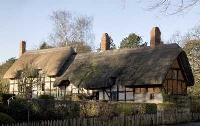
Pick-Up Points

Click the compass icons to preview pickups.

↑ Return to Top - Contact Us - F.A.Q. - Coach Operators - Group Bookings - Hotels - Attractions - Sitemap - Home
© CoachBookings.com 2026 - Company no. 5808080 - Privacy Policy - GDPR Compliance - Terms & Conditions
CoachBookings.com, 17 Birley Street, Blackpool, FY1 1EG, United Kingdom. 0345 33 11 080
CoachBookings.com, 17 Birley Street, Blackpool, FY1 1EG, United Kingdom. 0345 33 11 080