
You are here: Home » Sight Seeing » Charming Cotswolds at Easter
Charming Cotswolds at Easter
| Destination: Cotswolds | Operator: Crusader Holidays Terms |
| Departs: 03/04/2026 | Type: Sight Seeing |
| Duration: 4 days | Quality: Good * * * |
| Departs Via: All Areas | Board: Half Board |
| Tour Code: J2862609 | Transport: Coach Pickup |
Adults £479.00
Deposit Per Person £75.00
* Children: Not allowed
* Babies: Not allowed
Deposit Per Person £75.00
* Children: Not allowed
* Babies: Not allowed
20 rooms are available.
Cutoff Date: 19/03/2026
Description
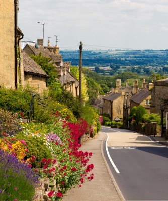
This Easter come and explore the Cotswolds, with its rolling hills, historic towns, and ancient stone cottages. The epitome of rustic charm and area of outstanding natural beauty covering six English counties, the Cotswolds is renowned for its rolling meadows, meandering river valleys, pretty woodland, gentle hillsides and of course its sleepy ancient limestone villages and market towns. The area hasn't changed much for over 300 years and is steeped in history, growing up on the prosperity of the medieval wool trade in the 15th and 16th century as attested by its many fine churches and manor houses. The Cotswolds have always been looked upon as the heart of England, with unsurpassed idyllic charm and breath-taking scenery at every turn.Itinerary
Highlights - Hotel for 3 nights with breakfast & dinner- Tea / coffee after dinner- Porterage- Use of leisure facilities- Journey on Gloucestershire Warwickshire Steam Railway (one way)- Visit to Broadway- Scenic tour - Chipping Campden & Moreton-in-Marsh- En route visits to Stow on the Wold & Cirencester
Itinerary
DAY 1 - After joining your holiday coach, head to Stow on the Wold where time will be allowed for lunch and sightseeing. At nearly 800ft, Stow is the highest of the Cotswold towns, located on the Roman Fosse Way and at the point where several roads meet, hence an important trading centre. It has a long history, it probably dates from a prehistoric fortified settlement on top of the hill and had a special importance in the English Civil War, the last battle was fought close by in Donnington back in 1646. St Edward's Church, was used as a prison for the defeated Royalist troops and some of the damage sustained at this time can still be seen today. Arrive at 4* Delta by Marriott Cheltenham Chase for the next 3 nights DBB\n\nDAY 2 - 3 - At leisure with two included excursions\n\nSCENIC COTSWOLD DRIVE\nHead out into the Cotswolds and enjoy the scenery and Spring colours to arrive in Chipping Campden where a stop will be made. Chipping Campden is one of the best preserved and most historically important towns in the Cotswolds. A planned town of the late 12th century, its original layout can still be traced along the High Street following the line of an important trading route. The ancient word 'chipping' refers to the market. Time here to look around before continuing onto Moreton-in Marsh with its broad High Street, lined with elegant 17th and 18th century buildings. The White Hart Royal is a former manor house in which King Charles I sheltered during the Civil War. The rare Curfew Tower still has its original clock and bell. The elegant Cotswolds stone buildings house many specialist shops, antique emporiums and tea rooms. Re-board the coach for a scenic drive back to the hotel.\n\nGLOUCESTERSHIRE WARWICKSHIRE RAILWAY & BROADWAY\nEnjoy a heritage railway through the spectacular scenic Cotswolds (may operate by steam and diesel) from Cheltenham Race Course to pretty Broadway, the 'Jewel of the Cotswolds' (journey time approx. one hour). The Gloucestershire Warwickshire Steam Railway covers 14 miles and commands wonderful views of the nearby sleepy hamlets and villages, with outstanding outlooks across to the Malvern Hills and beyond. Disembark in Broadway, at the GWSR station built by volunteers in the style of the original which was completely demolished when the line closed. Time at leisure in the quaint, picture-postcard Broadway, at the base of the Worcestershire hills in an AONB. Broadway today remains as it has done for centuries; a charismatic spectacle of rolling wolds, overlooking a gathering of ancient honey coloured limestone period buildings with orderly horse chestnut trees lining the grass-fringed verges of the historic 'broad way' High Street.\n\nDAY 4 - After breakfast, it's time to head homeward with a final stop in Cirencester, the 'Capital of the Cotswolds' with ancient honey coloured stone buildings in picturesque narrow streets. With many happy memories head back to interchange and onward to your home towns.
Venue Information
Delta by Marriott Cheltenham Chase \n\n4* Delta by Marriott Cheltenham Chase is a contemporary Gloucestershire retreat, set in 15 acres of private grounds on the edge of the picturesque Cotswolds Hills, approximately 5 miles from Cheltenham. \n\nThere is an excellent spa with an indoor swimming pool, steam room and spa bath. \n\nThe restaurant and bar are open plan with spacious areas offering impressive views over the grounds. \n\nThere is a lift as well as ground-floor rooms and singles are double for sole use. Guest bedrooms are stylish with all mod cons including tea / coffee making facilities. \n\nIf required, spa treatments (at additional cost) should be booked in advance with the hotel direct.
Pick-Up Points

Click the compass icons to preview pickups.

↑ Return to Top - Contact Us - F.A.Q. - Coach Operators - Group Bookings - Hotels - Attractions - Sitemap - Home
© CoachBookings.com 2026 - Company no. 5808080 - Privacy Policy - GDPR Compliance - Terms & Conditions
CoachBookings.com, 17 Birley Street, Blackpool, FY1 1EG, United Kingdom. 0345 33 11 080
CoachBookings.com, 17 Birley Street, Blackpool, FY1 1EG, United Kingdom. 0345 33 11 080