0345 33 11 080
CoachBookings Logo
Bookings for this holiday are now closed
You are here: Home » Sight Seeing » Norwich & the Broads

Norwich & the Broads

Destination: NorfolkOperator: Crusader Holidays Terms
Departs: 06/06/2011Type: Sight Seeing
Duration: 5 daysQuality: Good * * *
Departs Via: South EastBoard: Half Board
Tour Code: J12463Transport: Coach Pickup
Supplements
Single Room £72.00 per person
Adults £324.00
Deposit Per Person Payment required in full
* Children: Not allowed
* Babies: Not allowed
Sorry! This trip has sold out.
Description
Explore Norwich and its mix of quaint and new shops and traditional market. The breathtaking Norfolk Broads are a unique patchwork of rivers and lakes providing a network of waterways of beauty.
Itinerary
DAY 1 Departure:
A morning departure stopping en-route at the Suffolk market town of Bury St Edmunds, with free time for lunch before we continue to Norwich.

DAYS 2-4 At leisure
With one optional and two included excursions.

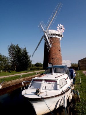
Wroxham and Horning:
We journey to the Norfolk Broads, firstly visiting Wroxham. In the afternoon we visit quaint Horning. Enjoy an optional relaxing boat trip on this wildlife protected area of vast inland waterway. The Broads were formed in Medieval times when areas dug for peat were later flooded. Used by Victorians for transporting goods via barge, today the Broads are home to numerous holiday pleasure crafts.

DAYS 2-4 At leisure
With one optional and two included excursions.

Cromer and Wells next the Sea:
We visit North Norfolk’s costal town of Cromer, the summer resort for rich banking families in the early 19th Century. The town’s popularity increased with the later introduction of the well known ‘Cromer Express’. See the landmark Hotel de Paris on the sea front, or try some famous Cromer Crab. We take the costal route back to the hotel, stopping in Wells next the Sea.

Optional* excursion - Norwich City Tour:
Today you have free time to wander at leisure in Norwich, one of the top ten shopping destinations in Britain. Why not join our optional guided City tour of this historical place.

LAST DAY Travel home via Bressingham Steam & Gardens:
We depart for home, en route visiting Bressingham Gardens and Steam Museum. Wander the beautiful grounds or visit the Locomotive sheds which bring the power and glory of mighty steam engineering up close. We arrive home in the evening.
Venue Information
Oaklands Hotel, Norwich

A warm welcome awaits you at this family owned hotel on the outskirts of Norwich. In beautiful grounds overlooking the Yare River Valley this hotel offers 49 en suite bedrooms with TV and tea & coffee making facilities. The hotel does not have a lift. Porterage, welcome drink and tea/coffee after dinner are included and enjoy a complimentary glass of wine one evening.
Picture: Click to ViewPicture: Click to View
Pick-Up Points
.Ashford The Prince Albert Roundabout Map
.Attleborough Outside HSBC Bank Map
.Barking Longbridge Road Bus Stop Map
.Basildon Coach Stop Outside Trafford House Map
.Beckenham Bus Stop Opposite Wimpy Map
.Beddington Broadway Bus Stop Opposit Plough Public House Map
.Bexhill On Sea Town Hall Square Bus Layby Map
.Bexleyheath Central Library Map
.Billericay Bus Stop Map
.Birchanger M11 Services Coach Park Map
.Bishops Stortford Station Approach Map
.Blythburgh A12 White Hart Public House Map
.Brentwood Bus Stop Near KFC Map
.Brighton St Peters Church Bus Stop Map
.Bromley Bromley North Railway Station Map
.Buckhurst Hill Outside Premier Inn Map
.Bury St Edmunds Bus Stop Outside Tesco Map
.Cambridge Bus Stop Outside Railway Station Map
.Canterbury Outside Canterbury East Railway Station Map
.Carshalton Bus Stop Near Post Office Map
.Chalkwell Park Bus Stop Map
.Chatham Go Outdoors Bus Stop, Adjacent To Gala Bingo Map
.Cheam Bus Stop A Map
.Chelmsford Coach Bay Map
.Cheshunt Turners Hill (B176) Map
.Christchurch Bus Stop Opposite Sommerfields Map
.Clacton On Sea Crusader Business Park Map
.Clacton-on-Sea Outside Railway Station Map
.Colchester Outside Gala Bingo Map
.Crawley Bus Station, Stand E Map
.Crayford Opposite Town Hall Map
.Crays Hill Shepard & Dog Public House Map
.Crowborough Jades Palace Restaurant Map
.Croyden Nestle Tower Bus Stop KC Park Park Lane Map
.Dagenham Outside Morrisons Map
.Dartford Civic Centre Bus Stops Map
.Dover Dover Passenger Terminal Map
.Duxford Bus Stop Imperial War Museum Map
.Eastbourne Outside Pier Entrance Map
.Eltham Rail Station Bus Terminus Map
.Enfield Town Southbury Road Bus Stop Map
.Enfield Outside U G C Cinema Map
.Ewell Bus Stop Opposite Bourne Hall Map
.Faversham Bus Stop Outside Sports Gnd Map
.Ferndown Lay By Ringwood Road A348 Bus Stop Map
.Folkestone Bus Stop Outside BP Garage Map
.Frinton On Sea Bus Stop Adjacent To Railway Station Map
.Gants Hill Outside Network Q Map
.Gillingham Bus Stop Map
.Gorleston The Library Map
.Gravesend Layby Outside Sainsburys Map
.Grays The Oak Public House Map
.Great Yarmouth Vauxhall Railway Station Map
.Hadleigh Hadleigh Church Bus Stop Map
.Halisham Bus Layby Map
.Harlow Bus Station, Near Taxi Rank Map
.Hastings Summerfield Sports Centre Map
.Hatfield Galleria Centre Main Entrance Bus Stop Map
.Hemel Hempstead Outside Bus Station Map
.Holland On Sea The Roaring Donkey Map
.Hornchurch North Street Queens Theatre Bus Stop Map
.Hove Bus Stop Outside Town Hall Map
.Ipswich Railway Station Map
.Kelvedon Railway Tavern Bus Stop Map
.Kessingland Post Office Map
.Kingston Bus Stop B4 Map
.Kirby Cross Bus Stop Opposite Railway Station Map
.Larkfield Bus Stop Outside The Wealden Hall Restaurant Map
.Leigh On Sea Outside The Elms Public House Map
.Leigh Bus Stop Map
.Loughton Trapps Hill Bus Stop Map
.Lowestoft Bus Stop Outside Railway Station Map
.Mildenhall Barton Mills A11 Little Chef Travel Lodge Map
.New Eltham Bus Stop Opp Railway Station Map
.Newmarket Bus Stop Palmers Map
.Norwich Bus Layby John Lewis Map
.Pakefield Tramway Hotel Map
.Pease Pottage M23 Services Map
.Pitsea Gala Bingo Club Map
.Polegate Bus Stop Outside St George Church Map
.Ponders End Tescos Map
.Potters Bar Bus Stop Junction Of Southgate Road Map
.Rainham Outside Cricketers PH Map
.Ramsgate Railway Station Map
.Rayleigh Outside Railway Station Map
.Redhill Bus Station Map
.Rochester Bus Lay By Near Dickens Centre Map
.Romford Bus Stop H Map
.Sawbridgeworth White Lion Public House Map
.Sevenoaks Bus Terminus, Entrance Off High Street Map
.Shoeburyness Bus Stop Inside Asda Map
.Sidcup Police Station Bus Stop Map
.Sittingbourne Railway Station Map
.South Benfleet New Bus Stop Map
.South Mimms M25/A1M Services Coach Park Map
.Southchurch Outside White Horse Map
.Southend Victoria Circus Bus Stop Map
.St Albans Bus Stop Outside DM Jewellers Map
.Strood Bus Stop Map
.Sutton Bus Stop L Opposite Police Station Map
.Thetford Minstergate Bus Station Map
.Thorpe Bay Railway Station Map
.Thurrock Moto Services Coach Park Map
.Tolworth Bus Stop F, Outside Marks & Map
.Tonbridge Bus Layby Map
.Tunbridge Wells Bus Stop B Near Railway Station Map
.Uckfield Bus Station Map
.Upminster Bus Stop A Opp. Railway Station Map
.Walthamstow Bus Stop Opposite Hospital Map
.Watford Watford Railway Station Map
.Westcliff Palace Theatre Map
.Whitstable Oxford Bingo Club Map
.Wickford Halls Corner Map
.Winchester Bull Drove Bar End Road Map
.Witham Lloyds The Chemist Map
.Woodford Green Bus Stop Opposite Castle Public House Map
.Worthing Outside Central Railway Station Map
.Wrentham A12 Village Bus Stop Map
.Wymondham Bus Stop Map
.Yoxford National Express Stop Map
Click the compass icons to preview pickups.
↑ Return to Top - Contact Us - F.A.Q. - Coach Operators - Group Bookings - Hotels - Attractions - Sitemap - Home