0345 33 11 080
CoachBookings Logo
Bookings for this holiday are now closed
You are here: Home » Festive Breaks » Turkey & Tinsel in North Wales

Turkey & Tinsel in North Wales

Destination: North WalesOperator: Crusader Holidays Terms
Departs: 13/11/2023Type: Festive Breaks
Duration: 5 daysQuality: Good * * *
Departs Via: All AreasBoard: Half Board
Tour Code: D44325Transport: Coach Pickup
Adults £419.00
Deposit Per Person £50.00
* Children: Not allowed
* Babies: Not allowed
This holiday has been cancelled
Description
Time to get festive in North Wales in lovely Llandudno. Situated between the Great and Little Orme headlands, the seafront is perfectly framed and complemented by a wonderful promenade where you can stroll to blue those winter cobwebs away. The pier is the longest in Wales (2295 feet, 700 metres).
Itinerary
Your Itinerary
Day 1 - Join your tour coach and head to North Wales with comfort stops en route. Accommodation at the welcoming Four Oaks Hotel. Dinner, bed & breakfast for 4 nights with festive extras, seasonal meals and plenty of pre-Christmas fun. During your stay you can expect a visit from Santa, a sherry reception and wine served with your 'Christmas' dinner.

Day 2 - 4 At leisure in Llandudno with two included excursions

INCLUDED EXCURSIONS
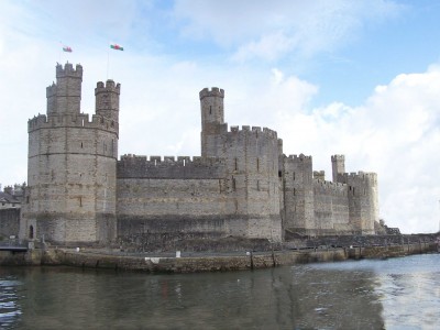
Coastal Forts and The Isle of Anglesey
First to Caernarfon, where the Prince of Wales was invested at its fantastical castle. Explore the cobbled lanes within the old walled town before crossing the glistening Menai Straits to 'Ynys Mon' (the Isle of Anglesey). Make a stop at Llanfair Pwllgwyngyll and then onto the elegant seaside town of Beaumaris, fronted by its superb 13th century moated castle

Llangollen
This ancient market town is a great place to visit. The River Dee runs through the town with the famous Dee Bridge built in 1345. You will find a vibrant shopping culture and café scene, with plenty of shops to browse and tea rooms to relax and soak up the serene surroundings. On the return journey spectacular views of the Horseshoe Pass

Day 5 - After breakfast head back to interchange and onward to your home towns
Venue Information
Hotel in Llandudno .
Four Oaks Hotel, Llandudno
The modest and friendly 2* Four Oaks Hotel occupies an excellent location on the main promenade overlooking the seafront and close to the modern shopping complex. The entrance is flat with no steps. There is a small old fashioned 'cage' style lift. Comfortable bedrooms offer TV and tea / coffee making facilities. The restaurant has sea views and there is a bar. (Supplement applies for rooms with seaview)
Hotel/Attraction Links
Picture: Click to ViewPicture: Click to ViewPicture: Click to View
Pick-Up Points
.Amersham Bus Stop, Railway Station End Map
.Ashford Bus Stop Opposite Catholic Church Map
.Aston Clinton Bus Stop,ADJ Layby Map
.Aylesbury Bedgrove Layby By Jansel Square Map
.Aylesbury Bus Shelters E2 & E3 Map
.Basildon Coach Stop Outside Trafford House Map
.Beaconsfield Beaconsfield Services, Coach Bays Map
.Beckenham Bus Stop Opposite Wimpy Map
.Berkhamsted Bus Stop Outside WHSmith Map
.Bexleyheath Central Library Map
.Bicester Outside JB Barbers Map
.Billericay Bus Stop Map
.Birchanger M11 Services Coach Park Map
.Bletchley Bus Station Map
.Brentwood Bus Stop - Near Holiday Inn Map
.Brighton Bus Stop Opposite Joker PH Map
.Bromley Bromley North Railway Station Map
.Buckhurst Hill Outside Premier Inn Map
.Bury St Edmunds Tesco St Saviours Interchange Map
.Canterbury Canterbury East Railway Station Map
.Chatham Go Outdoors Bus Stop, Adjacent To Gala Bingo Map
.Chelmsford Coach Bay Map
.Chesham Bus Stop Map
.Cheshunt Turners Hill (B176) Map
.Clacton On Sea Bus Stop Plough PH, Map
.Clacton-on-Sea Outside Railway Station Map
.Cobham Cobham Services Map
.Colchester Coach Stop Stand A Map
.Croyden Nestle Tower Bus Stop KC Park Park Lane Map
.Dartford Bus Stop Opposite Aldi Map
.Dover Bus Stop A Map
.Dunstable Bus Stop Outside Poundland Map
.Eltham Railway Station Bus Terminus Map
.Faversham Bus Stop Opp Makenade Ave Map
.Folkestone Bus Stop Outside BP Garage Map
.Fourwent Ways Burger King Map
.Frinton On Sea Bus Stop Adjacent To Railway Station Map
.Gravesend Bus Stop Opp. Sainsbury's Petrol Station Map
.Grays The Oak Public House Map
.Haddenham Bus Stop Map
.Harlow Bus Station, Near Taxi Rank Map
.Hatfield Galleria Centre Main Entrance Bus Stop Map
.Hazlemere A404 Opp, Hazelmere Court, Outside Shell Garage Map
.Hemel Hempstead Bus Stop M Map
.High Wycombe The Coachway, Bus Stop A Map
.Holland On Sea The Roaring Donkey Map
.Hornchurch North Street Queens Theatre Bus Stop Map
.Ipswich Railway Station Map
.Kelvedon Bus Stop Outside The Institute Map
.Kirby Cross Bus Stop Opposite Railway Station Map
.Leighton Buzzard Bus Stop Outside Halifax Map
.Loughton Trapps Hill Bus Stop Opposite Morrisons Map
.Luton Travel Lodge Map
.Maidenhead Outside Stafferton Lodge Map
.Maidstone Bus Stop Adj To Moncktons Lane Map
.Marks Tey Bus Stop Outside Fish & Chip Shop Map
.Milton Keynes Bus Shelter W3 O/s Weatherspoons Map
.Newmarket Bus Stop Outside Unico Pizzeria Ristorante Map
.Newport Pagnell Tickford End Bus Stop, Opposite Downs Field Map
.Northchurch Darrs Lane Bus Stop Map
.Olney Bus Stop Opposite The Bull Hotel Map
.Oxford Pear Tree Pear Tree Services In Front Of Waitrose Map
.Oxford Bus Stop Outside Connells Estate Agents Map
.Pease Pottage M23 Services Map
.Princess Risborough George & Dragon PH Map
.Rainham Outside Cricketers PH Map
.Rayleigh Outside Railway Station Map
.Reading Gateway Layby Opposite Burger King Map
.Redbridge Outside Tube Station Map
.Reigate Bus Stop R - Outside Buenos Aires Steakhouse Map
.Rochester Bus Lay By Near Dickens Centre Map
.Romford Bus Stop H Map
.Sevenoaks Bus Layby O/S Rail Station Map
.Sittingbourne Bus Stop Outside Railway Station Map
.Slough Salt Hill Three Tuns, Opposite Metro Bank Map
.South Benfleet New Bus Stop Map
.South Mimms M25/A1M Services Coach Park Map
.St Albans Bus Stop Outside DM Jewellers Map
.Strood Bus Stop By Prince Of Wales Map
.Thame Bus Layby Outside Town Hall Map
.Thurrock Moto Services Coach Park Map
.Tring Bus Shelter Near Church Map
.Tunbridge Wells Bus Stop B Near Railway Station Map
.Upminster Bus Stop A Opp. Railway Station Map
.Waltham Cross Hertford Road Bus Stop Map
.Watford Bus Stand One, Watford Junction Station Map
.Wendover The George & Dragon PH Map
.Wheatley M40 Services - Coach Layby Map
.Wickford Halls Corner Map
.Witham Newland Street Map
.Wokingham Railway Interchange, Stop 1 Map
.Woodford Green Bus Stop Opposite Castle Public House Map
Click the compass icons to preview pickups.
↑ Return to Top - Contact Us - F.A.Q. - Coach Operators - Group Bookings - Hotels - Attractions - Sitemap - Home