
You are here: Home » Festive Breaks » Bath Christmas Market
Bath Christmas Market
| Destination: Bath | Operator: Grindles Coaches Ltd Terms |
| Departs: 03/12/2026 | Type: Festive Breaks |
| Duration: 1 day | Quality: Good * * * |
| Departs Via: South West | Transport: Coach Pickup |
| Tour Code: D3820104 |
OAPs £19.00
Adults £19.00
Children £19.00
Deposit Per Person Payment required in full
* Children: Max age 16
* Babies: Not allowed
Adults £19.00
Children £19.00
Deposit Per Person Payment required in full
* Children: Max age 16
* Babies: Not allowed
24 seats are available.
Cutoff Date: 19/11/2026 00:00
Description
Immerse yourself in the festive spirit with a magical day trip to the Bath Christmas Markets, set against the backdrop of the city's historic charm. Stroll through over 150 beautifully adorned wooden chalets lining the streets, offering unique gifts, handmade crafts, and local treats. Savour seasonal delights like mulled wine, roasted chestnuts, and mince pies as the scent of Christmas fills the air.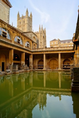
Pick-Up Points

Click the compass icons to preview pickups.

↑ Return to Top - Contact Us - F.A.Q. - Coach Operators - Group Bookings - Hotels - Attractions - Sitemap - Home
© CoachBookings.com 2026 - Company no. 5808080 - Privacy Policy - GDPR Compliance - Terms & Conditions
CoachBookings.com, 17 Birley Street, Blackpool, FY1 1EG, United Kingdom. 0345 33 11 080
CoachBookings.com, 17 Birley Street, Blackpool, FY1 1EG, United Kingdom. 0345 33 11 080