
You are here: Home » City Breaks » Moreton In Marsh Market
Moreton In Marsh Market
| Destination: Gloucestershire | Operator: Grindles Coaches Ltd Terms |
| Departs: 17/11/2026 | Type: City Breaks |
| Duration: 1 day | Quality: Good * * * |
| Departs Via: South West | Transport: Coach Pickup |
| Tour Code: D3820103 |
OAPs £18.50
Adults £18.50
Children £18.50
Deposit Per Person Payment required in full
* Children: Max age 16
* Babies: Not allowed
Adults £18.50
Children £18.50
Deposit Per Person Payment required in full
* Children: Max age 16
* Babies: Not allowed
52 seats are available.
Cutoff Date: 03/11/2026 00:00
Description
Set in the heart of the beautiful North Cotswolds, Moreton-in-Marsh is a classic market town brimming with honey-coloured stone buildings, welcoming cafés, and centuries of trading tradition. Its famous Tuesday market is one of the largest and oldest in the Cotswolds — a lively event that draws visitors from near and far.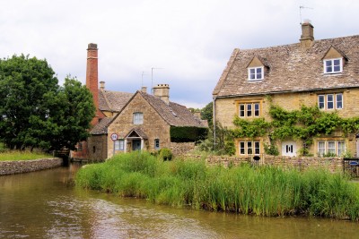
Pick-Up Points

Click the compass icons to preview pickups.

↑ Return to Top - Contact Us - F.A.Q. - Coach Operators - Group Bookings - Hotels - Attractions - Sitemap - Home
© CoachBookings.com 2026 - Company no. 5808080 - Privacy Policy - GDPR Compliance - Terms & Conditions
CoachBookings.com, 17 Birley Street, Blackpool, FY1 1EG, United Kingdom. 0345 33 11 080
CoachBookings.com, 17 Birley Street, Blackpool, FY1 1EG, United Kingdom. 0345 33 11 080