0345 33 11 080
CoachBookings Logo
Bookings for this holiday are now closed
You are here: Home » Sight Seeing » GOLD - Warner Norton Grange Coastal Village

GOLD - Warner Norton Grange Coastal Village

Destination: Isle of WightOperator: Grand UK Holidays Terms
Departs: 08/05/2023Type: Sight Seeing
Duration: 5 daysQuality: Good * * *
Departs Via: All AreasBoard: Half Board
Tour Code: J37328Transport: Coach Pickup
Adults £569.00
Deposit Per Person Payment required in full
* Children: Not allowed
* Babies: Not allowed
Sorry! This trip has sold out.
Description
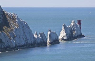
Highlights: Alum Bay, Godshill, Sandown and Shanklin, Cowes
We have chosen some fabulous Warner Hotels to host our prestigious Grand UK Gold programme in 2023. Warner is the leader in holiday destinations designed exclusively for adults, where you can enjoy doing as little or as much as you like. Take part in the numerous leisure activities on offer or quietly explore the grounds of these magnificent former country houses. Relax in the many bars and lounges with new found friends, or let the award winning Warner entertainments team provide both fun and laughter by day and night. And we have also included three sightseeing excursions for those who wish to get out and about and explore the surrounding area.
Itinerary
Excursions
FULL DAY:Ventnor and Godshill
FULL DAY:Sandown and Shanklin
HALF DAY:Ryde


Everything Included - Holiday Villages

- Free local joining points
- Collect Coach Miles
- All coach travel
- Reserved seats on tour coaches
- Tour Managerescorted
- Hotel/chalet accommodation and board as stated
- No single room supplement
- Excursions/itinerary as stated
- Admission fees and entertainment if stated
- Complete luggage handling
- Price-Back Insurance Offer


Pick-up Arrangements
01603 886767
For details on your pick up arrangements please click here.
Venue Information
Warner Norton Grange Coastal Village, IOW
Overlooking the Solent, Norton Grange is about a mile from the port of Yarmouth, nestled on the Isle of Wight coastline where you can easily watch the yachts sail by or take a stroll along the sea wall, while enjoying sightseeing excursions by coach to explore the pretty Diamond Isle.


- Standard en-suite chalet bedrooms
- Free Wi-Fi available
- Indoor heated swimming pool
- Daytime activities: archery, bowls, shooting, Nordic walking, fencing, aqua aerobics
- Live entertainment every night
- No lift, all chalets on the ground and first floor
Hotel/Attraction Links
Picture: Click to ViewPicture: Click to View
Pick-Up Points
.Acton Outside West London Trade Union Club Map
.Andover Outside Whitehart Hotel Map
.Ashford Bus Stop A Map
.Attleborough Outside HSBC Bank Map
.Baisingstoke Bus Layby Outside Sainsburys Map
.Banbury Bus Stop Outside Whately Hall Hotel Map
.Barking Opposite The Broadway Theatre Map
.Barnet Outside Everyman Cinema (previously ODEON Cinema) Map
.Basildon Coach Stop Outside Trafford House Map
.Beccles Old Market Place Map
.Beckenham High Street/ Kelsey Square Bus Stop By HSBC Map
.Bedford Bus Stop R1, Outside Bedford Train Station Map
.Bexley Almshouses Map
.Bexleyheath Outside Library Map
.Bicester Outside JB Barbers Map
.Biggleswade Bus Station Map
.Billericay Bus Stop Opposite Burghstead Close Map
.Bishops Stortford Bus Interchange Map
.Blackheath Bus Stop Map
.Bletchley Bus Station Map
.Bognor Regis Outside Railway Station Map
.Bourne The Bus Station Map
.Bracknell Bus Station Bay 3 Map
.Braintree Bus Stop Outside Job Centre Map
.Brentwood Bus Layby Warley Hill Map
.Brighton Bus Stop Z Map
.Broadstairs Piermont Hall Map
.Bromley Outside Bromley South Railway Station Map
.Buckingham Hospital Entrance Map
.Bury St Edmunds Bus Station Map
.Camberley Opposite Railway Station Map
.Cambridge Coach Bay Opposite The Arundal House Hotel Map
.Canterbury Coach Stop Opposite Snooker Club Map
.Carshalton Bus Stop Map
.Catford Bus Stop Outside Catford Bridge Tavern Map
.Chadwell Heath Outside Police Station Map
.Chatham Railway Station Map
.Chelmsford Holiday Coach Stop Map
.Chichester Outside Foundry Public House Map
.Chingford Outside Rail Station Map
.Clacton-on-Sea Outside Railway Station Map
.Colchester Bus Stop Outside Colchester Rail Station Map
.Collier Row Outside KFC Map
.Corby Bus Stop 7, Near Church Map
.Crowborough The Cross Bus Stop Map
.Croydon Bus Stop Outside Library Map
.Crystal Parade Outside Petrol Station Map
.Dagenham Outside Morrisons Map
.Dartford Outside Library Map
.Daventry Bus Station Map
.Deal Bus Stop Map
.Dereham Bus Stop Outside Texco Extra Map
.Didcot Bus Stop Outside Subway Map
.Diss Bus Station Map
.Dorking Outside White Horse Hotel Map
.Dover Bus Stop A Map
.Dovercourt Railway Station Map
.Dunstable Saracens Head Public House Map
.Ealing Bus Stop N, Outside Xanadu Hotel Map
.Eastbourne Outside Pier Entrance Map
.Eastleigh Bus Station Map
.Edgeware Layby In Front Of Halifax Building Society Map
.Edmonton Opposite Police Station Map
.Eltham Outside Boots Map
.Ely Barton Road Car Park Map
.Enfield Bus Stop N, Outside Labrookes Map
.Epsom Bus Stop B, Opposite Clock Tower Map
.Farnham Opposite Bishops Table Hotel Map
.Finchley Bus Stop Outside North Finchley Bus Station Map
.Folkestone Bus Stop, Bouverie Road West Map
.Gravesend Bus Stop Y Map
.Grays The Oak Public House Map
.Great Yarmouth Bus Layby Map
.Greenford Opposite Police Station Map
.Guildford Guildford Railway Station, Bus Stop G Map
.Harlow Bus Station, Near Taxi Rank Map
.Harold Hill Opposite Swimming Pool Map
.Harold Wood Bus Stop C, Opposite Railway Station Map
.Harpenden Opposite Barclays Bank Map
.Harrow On The Hill Outside Sakonis Restaurant Map
.Hatfield Express Bus Stop Map
.Havant The Bus Station Map
.Hayes Outside Bingo Hall Map
.Hemel Hempstead Bus Stop M Map
.Herne Bay Bus Stop Outside Library Map
.Hertford The Dog & Whistle Map
.High Wycombe Outside Rail Station Map
.Hitchin Opposite Queen Street Car Park Map
.Hoddesdon Clock Tower Map
.Hornchurch Bus Stop D, Opposite Sainsbury's Car Park Map
.Horsham Outside Railway Station Map
.Hounslow Hounslow West Tube Station Map
.Huntington Mill Common Bus Station Map
.Ilford Outside Ladbrookes Map
.Ipswich Railway Station Map
.Kettering Coach Bay Map
.Kidlington Outside Black Horse Public House Map
.Kings Langley Opposite Rose & Crown Public House Map
.Kings Lynn Bus Station, Stand H Map
.Kingston Upon Thames Bus Stop P3, Outside Bentals Store Map
.Leatherhead Southside Bus Stop Map
.Leicester Bus Stand PC, St Nicholas Circle Map
.Leigh On Sea Outside The Elms Public House Map
.Lewisham Bus Stop V, Outside Quick Fit Map
.Leyton Bus Stop Outside Tesco Map
.Lowestoft Bus Stop Outside Railway Station Map
.Luton Railway Station Entrance Map
.Maidenhead Bus Stop Map
.Maidstone Bus Stop Outside West Rail Station Map
.Maldon All Saints Church Map
.Manningtree Outside Skinners Arms Map
.Margate Bus Stop D Clock Tower Map
.Mildenhall Bus Station Map
.Mill Hill Bustop Outside Sacred Heart Church Map
.Milton Keynes Bus Stop Z6 Map
.Morden Bus Layby Outside The China Garden Map
.New Malden Corner Of Malden Road Map
.Newmarket Outside Hughes Electrical Store Map
.Northampton Coach Park Opposite Police Station Map
.Northampton The Coach Park, Northampton Services Map
.Northholt Bus Stop Outside Post Office Map
.Norwich Bus Layby John Lewis Map
.Orpington Bus Stop Map
.Oxford Layby Outside Playhouse Theatre Beaumont Street Map
.Peterborough Acland Street Coach Park Map
.Polegate Bus Stop Outside St George Church Map
.Portsmouth Coach Bay, Opposite George Public House Map
.Rainham Outside Cricketers PH Map
.Ramsgate Harbour Parade Map
.Rayleigh Bus Lay By Crown Public House Map
.Reading Bus Layby Greyfriars Road Map
.Redbridge Outside Tube Station Map
.Redhill Outside Prezzos Restaurant, Opposite Sainsburys Map
.Rickmansworth Layby Outside Railway Station Map
.Romford Bus Stop H Map
.Royston Bus Layby Outside Bus Station Map
.Ruislip Ruislip Underground Station Forecourt Map
.Rushden Outside Orbitt Tyres Map
.Sevenoaks Bus Terminus, Entrance Off High Street Map
.Shepperton Bus Stop Opposite The Bakers Map
.Shoeburyness Bus Stop Inside Asda Map
.Shoreham By Sea Bus Layby Map
.Sidcup Iceland Map
.Sittingbourne Railway Station Map
.Slough Bus Stop B, Outside Bus Station Map
.South Mimms Coach Park Entrance Map
.Southampton National Express Coach Station Map
.Southend Victoria Circus Bus Stop Map
.Spalding Bus Station Map
.St Albans Coach Bay D City Rail Station Map
.St Neots Market Square Map
.Staines Bus Stop Outside Staines Railway Station Map
.Stevenage Outside Matalan Map
.Stowmarket Outside The Railway Station Map
.Stratford Bus Stop N, Outside Travelodge Map
.Streatham Outside United Reformed Church Map
.Surbiton Bus Stop By Rail Bridge Map
.Sutton Opposite Police Station Map
.Swanley Bus Stop Back Of Asda Map
.Thatcham Bus Stop, Outside McColls Store Map
.Thetford Minstergate Bus Station Map
.Thurrock Moto Services Coach Park Map
.Tonbridge Bus Layby Next To Public WC Map
.Tunbridge Wells Opposite The Assembly Halls Map
.Twickenham Outside Alsford Timber Map
.Uckfield Bus Station Map
.Upminster Bus Stop Outside St Lawrence Church Map
.Uxbridge Bus Stop W Map
.Walthamstow HSBC Map
.Watford Bus Stand One, Watford Junction Station Map
.Welwyn Garden City Entrance John Lewis Map
.Whistable Harbour Street Bus Stop Map
.Wickford Opposite Police Station Map
.Wimbledon Wimbledon Theatre Map
.Winchester King Alfred Statue Map
.Wisbech Horsefair Coach Stop Map
.Witham Lloyds The Chemist Map
.Wood Green Bus Stop C, Outside Arriva Bus Garage Map
.Worthing Outside Central Railway Station Map
.Wymondham National Express Coach Stop Map
Click the compass icons to preview pickups.
↑ Return to Top - Contact Us - F.A.Q. - Coach Operators - Group Bookings - Hotels - Attractions - Sitemap - Home