
Bookings for this holiday are now closed
You are here: Home » Coastal Breaks » Torquay & the English Riviera
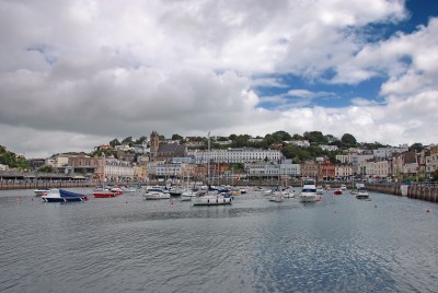
Torquay & the English Riviera
| Destination: Torquay | Operator: Crusader Holidays Terms |
| Departs: 26/09/2010 | Type: Coastal Breaks |
| Duration: 7 days | Quality: Good * * * |
| Departs Via: South East | Board: Half Board |
| Tour Code: S6435 | Transport: Coach Pickup |
Supplements
| Single Room | £120.00 per person |
Adults £495.00
Deposit Per Person Payment required in full
* Children: Not allowed
* Babies: Not allowed
Sorry, there's not enough time left to book you on this trip!
Deposit Per Person Payment required in full
* Children: Not allowed
* Babies: Not allowed
Sorry, there's not enough time left to book you on this trip!
Description
The English Riviera, with its 22 miles of coastline, cliffs, coves and beaches to explore and enjoy, has been one of the UK’s top holiday destinations since Victorian times.Itinerary
Day 1 DepartureA morning departure, stopping for lunch and refreshments en-route to our resort hotel.
Days 2-6 At leisure
At leisure in Torquay with two included and one optional excursion. The English Riviera, with its 22 miles of coastline, cliffs, coves and beaches to explore and enjoy, has been one of the UK’s top holiday destinations since Victorian times. See the sparkling white villas perched on the verdant hilltops, beautiful gardens around the seafront and elegant Victorian facades along the main streets. Along with its evident Victorian ancestry, Torquay is also a vibrant and forward-thinking resort attracting visitors of all interests, from Art and Culture aficionados to marine enthusiasts. Torquay’s waterfront is the focus of life in the town. Here you’ll find the palm-lined promenade, seafront gardens, a lively harbour and an international marina. Of the 19 beaches and coves of the English Riviera, some, close to the town centre are wide, open stretches of sand with beach facilities and many are smaller and more secluded.
Included Excursion
Full Day Devon Coast, Brixham & Dartmouth A full day included excursion along the famous Devon coast. The first stop is Brixham, an old and picturesque port. Then it is on to Dartmouth, another beautiful and well-preserved old port. We return to Torquay via the resort of Paignton.
Included Excursion
Half Day Plymouth A half day included excursion to Plymouth, the vibrant regional capital of Devon and Cornwall. This thriving modern city is also a historic seafaring port.
Optional Excursion
Half Day Dartmoor A half day optional excursion to experience the evocative atmosphere of Dartmoor, with visits to Princetown, the highest village on Dartmoor and Widecombe-in-the-Moor, set in the beautiful Widecombe Valley. In the village you can see Church House and the adjoining Sexton’s Cottage. The building dates back to the Sixteenth Century and is of architectural and historical interest.
Last Day Travel home
We depart for home, arriving during the evening.
Venue Information
Barceló Imperial Hotel TorquayThe Barceló Imperial Hotel is situated close to all amenities and the marina. This hotel boasts fantastic views over the bay. Facilities include a gym, indoor & outdoor swimming pool (May-September, subject to weather conditions), conservatory lounge, bar and restaurant with fantastic views. All bedrooms are en-suite with TV and tea & coffee making facilities.
Pick-Up Points

Click the compass icons to preview pickups.

↑ Return to Top - Contact Us - F.A.Q. - Coach Operators - Group Bookings - Hotels - Attractions - Sitemap - Home
© CoachBookings.com 2026 - Company no. 5808080 - Privacy Policy - GDPR Compliance - Terms & Conditions
CoachBookings.com, 17 Birley Street, Blackpool, FY1 1EG, United Kingdom. 0345 33 11 080
CoachBookings.com, 17 Birley Street, Blackpool, FY1 1EG, United Kingdom. 0345 33 11 080