0345 33 11 080
CoachBookings Logo
Bookings for this holiday are now closed
You are here: Home » Sight Seeing » Liverpool & Port Sunlight

Liverpool & Port Sunlight

Destination: LiverpoolOperator: Crusader Holidays Terms
Departs: 15/07/2018Type: Sight Seeing
Duration: 5 daysQuality: Excellent * * * *
Departs Via: South EastBoard: Half Board
Tour Code: S32820Transport: Coach Pickup
Supplements
Single Room £110.00 per person
Adults R.R.P. £419.00 Our Price £409.00
Deposit Per Person £75.00
* Children: Not allowed
* Babies: Not allowed
Sorry, there's not enough time left to book you on this trip!
Description
Liverpool, famous as the birthplace of the Beatles, and in the Guinness Book of Records as the official World Capital of Pop. The highlight of this tour is a visit to Lord Lever’s Port Sunlight Village, a fascinating insight to life in the late 1800’s. The Lady Lever Art Gallery is dedicated to his wife’s memory, containing the best of Lever’s personal collection.
Itinerary
Day 1 - Journey northwards with comfort stops en-route to arrive in Liverpool late afternoon for your 4 night stay at the RMS Titanic Hotel. Dinner, bed & breakfast.


Days 2 - 4 – At leisure in Liverpool with two included excursions.


INCLUDED EXCURSIONS

Liverpool (2 days)

All board for an informative guided tour of Liverpool with a local guide and then free time to sightsee at leisure. A further day is included for you to explore the many attractions of this fascinating city.

Port Sunlight Village & Ness Botanic Gardens

A morning visit to Lord Lever’s Port Sunlight Village. Museum entry included. Return to the hotel in time to freshen up before dinner.

Enjoy a visit to the superb award-winning gardens at Ness, situated on the Wirral Peninsula overlooking the Dee Estuary. Founded in 1898 by Arthur Kilpin Bulley, a local cotton merchant with a passion for plant collecting, the gardens were donated to The University of Liverpool in 1948 by his daughter.

Ness is open all year round with seasonal flowers, shrubs and trees, a beautiful rock garden, enchanting Laburnum arch and spectacular herbaceous border.


Day 5 - After a hearty breakfast return southwards, making a lunchtime stop on the way home.
Venue Information
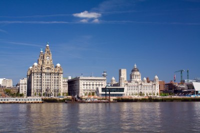
RMS Titanic Hotel, 30 James Street, Liverpool

Situated opposite the Albert Dock, 30 James Street overlooks the Three Graces, which comprises of the Royal Liver, the Cunard, and the Port of Liverpool buildings. Once the home of the ill-fated White Star Line's (Titanic) headquarters, 30 James Street is ideally placed for exploring Liverpool and its many attractions. The hotel boasts a roof-top terrace, Champagne Bar and comfortable en-suite bedrooms with tea/coffee making. There is a lift to all floors.
Picture: Click to ViewPicture: Click to View
Pick-Up Points
.Amersham Bus Stop, Railway Station End Map
.Ashford Bus Stop Opposite Catholic Church Map
.Aston Clinton Bus Stop,ADJ Layby Map
.Attleborough Outside HSBC Bank Map
.Aylesbury Bedgrove Layby By Jansel Square Map
.Aylesbury Bus Shelters E2 & E3 Map
.Barking Longbridge Road Bus Stop Map
.Basildon Coach Stop Outside Trafford House Map
.Beckenham Bus Stop Opposite Wimpy Map
.Beddington Broadway Bus Stop Opposit Plough Public House Map
.Berkhamsted Bus Stop Outside WHSmith Map
.Bexhill On Sea Town Hall Square Bus Layby Map
.Bexleyheath Central Library Map
.Bicester Outside JB Barbers Map
.Billericay Bus Stop Map
.Birchanger M11 Services Coach Park Map
.Bletchley Bus Station Map
.Blythburgh A12 White Hart Public House Map
.Brentwood Bus Stop - Near Holiday Inn Map
.Brighton St Peters Church Bus Stop Map
.Bromley Bromley North Railway Station Map
.Buckhurst Hill Outside Premier Inn Map
.Cambridge Bus Stop Outside Railway Station Map
.Canterbury Outside Canterbury East Railway Station Map
.Carshalton Bus Stop Near Post Office Map
.Chalkwell Park Bus Stop Map
.Chatham Go Outdoors Bus Stop, Adjacent To Gala Bingo Map
.Cheam Bus Stop A Map
.Chelmsford Coach Bay Map
.Chesham Bus Stop Map
.Cheshunt Turners Hill (B176) Map
.Clacton On Sea Crusader Business Park Map
.Clacton-on-Sea Outside Railway Station Map
.Colchester Coach Stop Stand A Map
.Crawley Bus Station, Stand E Map
.Crayford Opposite Town Hall Map
.Crowborough Jades Palace Restaurant Map
.Croyden Bus Stop Map
.Dagenham Outside Morrisons Map
.Dartford Bus Stop Opposite Aldi Map
.Dorking Outside White Horse Hotel Map
.Dover Bus Stop A Map
.Dunstable Bus Stop Layby Map
.Duxford Bus Stop Imperial War Museum Map
.Eltham Rail Station Bus Terminus Map
.Enfield Town Southbury Road Bus Stop Map
.Ewell Bus Stop Opposite Spring Hotel Map
.Faversham Bus Stop Opp Makenade Ave Map
.Folkestone Bus Stop Outside BP Garage Map
.Fourwent Ways Burger King Map
.Frinton On Sea Bus Stop Adjacent To Railway Station Map
.Gants Hill Outside Network Q Map
.Gilliangham Bus Stop Nr Darland Ave, Esso Garage Map
.Gillingham Medway Services Map
.Gorleston The Library Map
.Gravesend Layby Outside Sainsburys Map
.Grays The Oak Public House Map
.Great Yarmouth Bus Layby Map
.Haddenham Bus Stop Map
.Hadleigh Bus Stop Opposite Fire Station Map
.Harlow Terminus Street Map
.Hastings Bus Stop Outside Summerfields Sports Centre Map
.Hatfield Galleria Centre Main Entrance Bus Stop Map
.Hazlemere A404 Opp, Hazelmere Court, Outside Shell Garage Map
.Hemel Hempstead Bus Staion Map
.Hemel Hempstead Bus Stop M Map
.Hemel Hempstead Outside Bus Station Map
.High Wycombe Bus Station Bay 18 Map
.High Wycombe Bus Stop, Layby ADJ Empire Cinema Map
.Holland On Sea The Roaring Donkey Map
.Hornchurch Outside Library Map
.Hove Bus Stop Outside Town Hall Map
.Ilford Outside Ladbrookes Map
.Ipswich Railway Station Map
.Kelvedon Bus Stop Outside The Institute Map
.Kessingland Post Office Map
.Kings Langley Outside GPO Sorting Office Map
.Kingston Bus Stop B4 Map
.Kirby Cross Bus Stop Opposite Railway Station Map
.Leigh On Sea Outside The Elms Public House Map
.Leighton Buzzard Bus Stop Outside Halifax Map
.Lowestoft Bus Stop Outside Railway Station Map
.Luton Travel Lodge Map
.Maidstone Bus Stop Adj To Moncktons Lane Map
.Marks Tey Bus Stop Opposite The Food Factory Map
.Martlesham Bus Stop Outside Tesco Map
.Mildenhall Barton Mills A11 Little Chef Travel Lodge Map
.Milton Keynes Bus Shelter W3 O/s Weatherspoons Map
.New Eltham Bus Stop Opp Railway Station Map
.Newmarket Outside Hughes Electrical Store Map
.Northchurch Darrs Lane Bus Stop Map
.Norwich Bus Layby John Lewis Map
.Oxford Headington Bus Stop Outside Coventry Building Society Map
.Oxford Pear Tree Pear Tree Services In Front Of Waitrose Map
.Pakefield Tramway Hotel Map
.Pease Pottage M23 Services Map
.Pitsea Gala Bingo Club Map
.Ponders End Tescos Map
.Potters Bar Bus Stop Junction Of Southgate Road Map
.Princess Risborough George & Dragon PH Map
.Rainham Outside Cricketers PH Map
.Rayleigh Outside Railway Station Map
.Redbridge Outside Tube Station Map
.Reigate Bus Stop R - Outside Buenos Aires Steakhouse Map
.Rochester Bus Lay By Near Dickens Centre Map
.Romford Bus Stop H Map
.Sevenoaks Bus Layby O/S Rail Station Map
.Shoeburyness Bus Stop Inside Asda Map
.Shoreham-by-sea Bus Stop Opp Dominos Pizza Map
.Sidcup Bus Stop R-Opp Morrisons Map
.Sittingbourne Railway Station Map
.South Benfleet New Bus Stop Map
.South Mimms M25/A1M Services Coach Park Map
.Southchurch Outside White Horse Map
.Southend Victoria Circus Bus Stop Map
.St Albans Bus Stop Outside DM Jewellers Map
.Strood Bus Stop Map
.Sutton Bus Stop L Opposite Police Station Map
.Thame Town Hall Bus Stop Map
.Thetford Minstergate Bus Station Map
.Thorpe Bay Railway Station Map
.Thurrock Moto Services Coach Park Map
.Tolworth Bus Stop F, Outside Marks & Map
.Tonbridge Outside Lidl Supermarket Quarry Hill Road Map
.Tring Bus Shelter Near Church Map
.Tunbridge Wells Bus Stop B Near Railway Station Map
.Uckfield Bus Station Map
.Upminster Bus Stop A Opp. Railway Station Map
.Waltham Cross Hertford Road Bus Stop Map
.Walthamstow Bus Stop Opp Hainault Court Map
.Watford Watford Railway Station Map
.Wendover The George & Dragon PH Map
.Westcliff Palace Theatre Map
.Wheatley M40 Services - Coach Layby Map
.Wickford Halls Corner Map
.Witham Lloyds The Chemist Map
.Woodford Green Bus Stop Opposite Castle Public House Map
.Worthing Outside Central Railway Station Map
.Wrentham A12 Village Bus Stop Map
.Wymondham Bus Stop Map
.Yoxford Layby On A12 Map
Click the compass icons to preview pickups.
↑ Return to Top - Contact Us - F.A.Q. - Coach Operators - Group Bookings - Hotels - Attractions - Sitemap - Home