
Bookings for this holiday are now closed
You are here: Home » Coastal Breaks » Torquay & the English Riviera
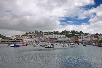
Torquay & the English Riviera
| Destination: Torquay | Operator: Crusader Holidays Terms |
| Departs: 27/08/2012 | Type: Coastal Breaks |
| Duration: 5 days | Quality: Good * * * |
| Departs Via: South East | Board: Half Board |
| Tour Code: S16575 | Transport: Coach Pickup |
Supplements
| Single Room | £50.00 per person |
Adults £325.00
Deposit Per Person Payment required in full
* Children: Not allowed
* Babies: Not allowed
Sorry, there's not enough time left to book you on this trip!
Deposit Per Person Payment required in full
* Children: Not allowed
* Babies: Not allowed
Sorry, there's not enough time left to book you on this trip!
Description
The English Riviera, with its mile after mile of beautiful coastline, cliffs, coves and beaches to explore and enjoy has been one of the UK’s top holiday destinations since Victorian times.HIGHLIGHTS
• Hotel for 4 nights with breakfast & dinner
• Two included excursion to Devon Coast, Brixham & Dartmouth and Plymouth
Itinerary
DAY 1 Departure: A morning departure, stopping for lunch en route to Torquay. Torquay is a vibrant resort and the waterfront is the focus of life in the town with a palm-lined promenade, a lively harbour and an international marina. DAYS 2-4 At leisure with two included excursions.
Devon Coast, Brixham & Dartmouth: Touring the Devon coast, visiting the old picturesque ports of Brixham and Dartmouth before returning to Torquay via Paignton.
Plymouth: This vibrant regional capital of Devon and Cornwall is a thriving modern city and a historic seafaring port.
LAST DAY Travel home: We depart for home, arriving during the evening.
Venue Information
Best Western Gleneagles Hotel, TorquayWith views across Ansteys Cove, this delightful hotel offered the inspiration behind the TV programme ‘Fawlty Towers’ and memorabilia remains on show in reception. All en suite bedrooms have balconies/patios, hairdryer and TV. There is an outdoor pool & terrace (open in summer). A lift is available and porterage is provided.
Pick-Up Points

Click the compass icons to preview pickups.

↑ Return to Top - Contact Us - F.A.Q. - Coach Operators - Group Bookings - Hotels - Attractions - Sitemap - Home
© CoachBookings.com 2026 - Company no. 5808080 - Privacy Policy - GDPR Compliance - Terms & Conditions
CoachBookings.com, 17 Birley Street, Blackpool, FY1 1EG, United Kingdom. 0345 33 11 080
CoachBookings.com, 17 Birley Street, Blackpool, FY1 1EG, United Kingdom. 0345 33 11 080