
Bookings for this holiday are now closed
You are here: Home » Touring Holidays » CRICCIETH 5 DAYS - GEORGE IV HOTEL
CRICCIETH 5 DAYS - GEORGE IV HOTEL
| Destination: North Wales | Operator: Alfa Travel Terms |
| Departs: 22/03/2010 | Type: Touring Holidays |
| Duration: 5 days | Quality: Good * * * |
| Departs Via: North West | Board: Half Board |
| Tour Code: M4373 | Transport: Coach Pickup |
Supplements
| Single Room | £22.00 per person |
Adults £154.00
Deposit Per Person Payment required in full
* Children: Not allowed
* Babies: Not allowed
Sorry, there's not enough time left to book you on this trip!
Deposit Per Person Payment required in full
* Children: Not allowed
* Babies: Not allowed
Sorry, there's not enough time left to book you on this trip!
Description
Criccieth must surely enjoy one of the most beautiful locations to be found anywhere. Situated on the coast at the edge of the Snowdonia National Park with all its attractions there is something to do for everybody. Castles, walks, mountains, beaches, scenery, trains, golf, water sports, fishing, plus excellent visitor attractions in abundance. Criccieth has two beaches either side of the Castle, which dominates the town standing high on its rocky perch. The beaches are a mixture of sand and pebble with a rocky area at the far end of the eastern beach exposing rock pools at low tide. There are no amusement arcades or vendors along these beaches so you can enjoy a relaxing time soaking up the sun with only the sounds of the sea.Itinerary
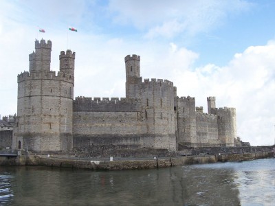
EXCURSIONS INCLUDEDFull Day Excursion to Caernarfon and Snowdonia
A magnificent journey today takes us along the coast to Pwllheli and then northwards to Caernarfon, with its magnificent castle beside the harbour. We then turn inland and travel to Llanberis, at the foot of Snowdon, and then over the maginicent Pass of Llanberis, with more spectacular views of Snowdon, before decsending to Beddgelert, and thence back to our hotel
Full Day Excursion to Harlech, Ffestiniog, and Porthmadog
Our excursion takes us firstly to Harlech, with its 13th century castle, then we travel to Blaenau Ffestiniog, once a major centre of the slate mining industry. We then continue onto Porthmadog, a harbour town on the Glaslyn estuary.
Venue Information
George IV Hotel This latest addition to the Leisureplex group is situated on the High Street in the centre of Criccieth with magnificent views towards the sea and castle from many bedrooms. All 47 bedrooms are centrally heated and have bath or shower and WC (mostly bath and WC), hair dryer, TV, intercom and tea/coffee making facilities. Extensive public areas include a delightful cocktail bar, a large restaurant, entertainment room with additional bar and a cosy lounge. A small lift serves first and second floors but not the third floor.
Hotel/Attraction Links
- Hotels
- George IV Hotel (Criccieth) - View Information
Pick-Up Points

Click the compass icons to preview pickups.

↑ Return to Top - Contact Us - F.A.Q. - Coach Operators - Group Bookings - Hotels - Attractions - Sitemap - Home
© CoachBookings.com 2026 - Company no. 5808080 - Privacy Policy - GDPR Compliance - Terms & Conditions
CoachBookings.com, 17 Birley Street, Blackpool, FY1 1EG, United Kingdom. 0345 33 11 080
CoachBookings.com, 17 Birley Street, Blackpool, FY1 1EG, United Kingdom. 0345 33 11 080