0345 33 11 080
CoachBookings Logo
Bookings for this holiday are now closed
You are here: Home » Coastal Breaks » PORTHCAWL 5 DAYS - SEABANK HOTEL

PORTHCAWL 5 DAYS - SEABANK HOTEL

Destination: CardiffOperator: Alfa Travel Terms
Departs: 13/02/2012Type: Coastal Breaks
Duration: 5 daysQuality: Good * * *
Departs Via: North WestBoard: Half Board
Tour Code: M15894Transport: Coach Pickup
Supplements
Single Room £24.00 per person
Adults £152.00
Deposit Per Person Payment required in full
* Children: Not allowed
* Babies: Not allowed
Sorry! This trip has sold out.
Description
Located between Swansea and Cardiff, Porthcawl was originally a port for the iron and steel industries and still has some interesting features from that period, including the oldest maritime warehouse in Wales, an attractive harbour and the last coal and gas powered lighthouse in the country. The attractive seaside resort offers numerous facilities, including the world famous Porthcawl golf course, the finest course in Wales and one of several in the area, an expansive sandy beach and Coney Beach, a fairground with a variety of rides and amusements which was named after the famous New York venue.
Itinerary
FIVE DAY (FOUR NIGHT) TOUR
EXCURSIONS INCLUDED
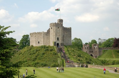
Full Day Tour to Cardiff and National Museum of Welsh Life
We travel the short distance to Cardiff and start the day with a guided sightseeing tour of the city included in the tour cost followed by a visit to the National Museum of Welsh Life, one of Europe’s premier open air museums and the most popular heritage attraction in Wales, featuring reconstructed buildings brought from all parts of Wales.

Full Day Excursion to Swansea, Mumbles and the Gower
Mumbles is a traditional Victorian seaside resort at the entrance to the Gower, a beautiful peninsula and Britain's first designated Area of Outstanding Natural Beauty. Swansea is a bustling city full of interest including the National Waterfront Museum and the Dylan Thomas Centre
Venue Information
Seabank Hotel

Porthcawl's most prominent building is situated on a headland, a short walk from the Grand Pavilion and John Street shops. There are spectacular views of the Bristol Channel and south Wales coast from the bar, restaurant and most bedrooms. All 67 bedrooms are centrally heated and have bath or shower and WC, hair dryer, trouser press, TV, intercom and tea/coffee making facilities. Extensive public areas include the cosy Smuggler’s Bar and Garden Restaurant with stunning views across the Channel to Somerset and Devon. The lift serves all floors. The extensive car park can accommodate over 120 cars. Tel: 01656 782261. AA Two Star. A Leisureplex Hotel

Note for clients with a mobility impairment: this hotel does not have any ground floor bedrooms. There are five steps to the front door, although level access is available through side entrances. Many rooms are level access from the lift, although some are several stairs from lift level. Please ensure you submit a Special Needs form if you are mobility impaired.
Picture: Click to ViewPicture: Click to View
Pick-Up Points
.Accrington Stand L Map
.Ainsdale Opposite Toby Grill Map
.Allerton Presbyterian Church, Smithdown Place Map
.Altrincham Bus Station-Stand A Map
.Ashton-In-Makefield Opposite Calderbanks Map
.Ashton-Under-Lyne Bus Station Map
.Atherton Opposite Puchbowl Map
.Bacup Bus Lay By Opposite Abbey National Map
.Bamber Bridge William Hill Bookmakers Map
.Barnsley Stand 23/24 Map
.Barrow In Furness St Marys Church Map
.Batley Outside Town Hall Map
.Birkenhead Coach Station Map
.Bispham Outside Inghams Solicitors Map
.Blackburn Boulevard Pub Map
.Blackpool Coach Station Bay 7 Map
.Bolton-Le-Sands Outside Royal Hotel Map
.Bolton Bus Station Map
.Bramley Bus Lay-by Opp Unicorn Map
.Brighouse Bus Station Map
.Bromsborough Outside Royal Oak Hotel Map
.Bucknall Finney Gardens Map
.Burnley Bus Stand 11 Map
.Bury Coach Stop Map
.Carnforth Opposite Carnforth Hotel Map
.Cheadle Opp Post Office Map
.Chester Outside Funeral Directors Map
.Chorley Cus Lay-by Outside Railway Station Map
.Cleckheaton Outside Jack's Fish & Chips Map
.Cleveleys Outside Nat West Bank Map
.Clitheroe Railway/Bus Interchange Map
.Colne Bus Station Map
.Congleton Fairground Map
.Crewe Opposite Delamere House Map
.Crosby Outside St Lukes Church Map
.Dalton-In-Furness Tudor Square Map
.Darwen Opposite Eathel Austins Map
.Denton Bus Lay-by Map
.Dewsbury Stand 18 Map
.Doncaster Stand C5/C6 Map
.Droylsden Concorde Suite Map
.Elland Bus Stand Nr Catherine St Map
.Ellesmere Port Bus Station Stand 9 Map
.Failsworth Opposite Pole Travel Map
.Farnworth, Bolton Bus Stop Opposite Woolworths Map
.Fleetwood Lay By Near Brihthouse Map
.Flint Outside Town Hall Map
.Formby Cross Green Map
.Freckleton Lay By Opposite Memorial Map
.Frodsham Outside Bear's Paw Map
.Garstang Bus Stop Opposite Coop Map
.Glossop Bus Shelter Map
.Halifax Bus Station, Platform E1-E3 Map
.Hanley ST1 3RF Sheltered Bus Stop, Hinde Street Map
.Helsby District Garage Bus Stop Map
.Heswall Outside Co-Op Travelcare Map
.Hunts Cross Bus Stop Map
.Huyton Bus Stop Opposite Dayrich Bookmakers Map
.Hyde New Taxi Rank Map
.Keighley Bus Layby Map
.Kendal Car Park Map
.Kidsgrove Harecastle Hotel Map
.Kirkby Lay-By Civic Offices Map
.Knutsford Toft Road, Map
.Lancaster Charter House Map
.Leek Bus Station Map
.Leigh, Pemberton Sunseekers Travel Map
.Leyland Bus Lay-by Opp Old Police Station Map
.Lindale Lindale Inn Map
.Litherland Outside Collonade Insurance Map
.Liverpool National Express Coach Station Map
.Longton Express Stop Map
.Lytham Queens Hotel Map
.Macclesfield Queens Hotel Map
.Maghull Central Square Map
.Manchester Boulton House Map
.Meir Opposite Co-op Map
.Middlewich Subway Bus Stop Map
.Milnthorpe Bulls Head Car Park Map
.Morecambe Central Bus Station Map
.Moreton The Cross Outside Abbey National Map
.Morley, Leeds Opposite Town Hall Map
.Nantwich Outside Civic Hall Map
.Nelson Bus Interchange Broadway Map
.Neston Somerfield Bus Stop Map
.Newcastle-Under-Lymn School St- Behind Swimming Pool Map
.Newton-Le-Willows Dragon & Phoenix Map
.Northwich Outside Memorial Hall Map
.Old Swan Black Horse Inn Map
.Oldham Stand C Bus Station Map
.Ormskirk Outside Websters Furnishing Map
.Poulton-Le-Fylde Bus Station Map
.Prescot Clock Face Public House Map
.Prestatyn Central Bus Station Map
.Preston Bus Station Map
.Queensferry Deeside Leisure Centre Map
.Ramsbottom Bus Stop Lay-by Adderston Mansion Map
.Rawtenstall West End Garage Map
.Rhyl Clock Tower Map
.Rochdale Outside Town Hall Map
.Rotherham Outside Trades Club Map
.Royton Main Post Office Map
.Runcorn Bus Station Old Town Map
.Sale Outside LA Fitness Map
.Sandbach Town Outside Military Arms Map
.Sheffield Stand E5/E6 Transport Interchange Map
.Shipley Market Street Map
.Shotton (Deeside) Outside Owens Travel Map
.Southport 53 London Street Map
.St Annes Ashton Garden Gate Map
.St Helens Birchley Street Map
.Stalybridge Bus Stop Opposite Church Map
.Standish Adj Globe Public House Map
.Stockport Stand C Map
.Stoke Vale Street Bus Stop Map
.Stretford Bus Stop-Opposite Arndale Centre Map
.Todmorden Halifax Building Society Map
.Trentham Outside Man In Space Public House Map
.Tunstall Police Station Map
.Ulverston Bus Station Map
.Urmston Bus Stop-OutSide Nags Head Map
.Wakefield Bus Station Map
.Walkden Outside Stocks Hotel Map
.Wallasey Outside Boot Inn Map
.Walton Outside Barnes Travel Map
.Warrington Golden Lion Map
.West Kirby Concourse Opposite Dee Hotel Map
.Whitchurch Brownlow Car Park Map
.Widness Victoria Square Map
.Wigan Coach Bay -opp Wigan College Map
.Winsford Bus Lay -By Outside Guild Hall Map
.Wolstanton Outside The Plough Map
.Wythenshawe Next To Gala Bingo Map
Click the compass icons to preview pickups.
↑ Return to Top - Contact Us - F.A.Q. - Coach Operators - Group Bookings - Hotels - Attractions - Sitemap - Home