0345 33 11 080
CoachBookings Logo
Bookings for this holiday are now closed
You are here: Home » Sight Seeing » Brittany & Mont St Michel

Brittany & Mont St Michel

Destination: FranceOperator: Crusader Holidays Terms
Departs: 30/05/2010Type: Sight Seeing
Duration: 7 daysQuality: Good * * *
Departs Via: South EastBoard: Full Board
Tour Code: J6650Transport: Coach Pickup
Supplements
Single Room £99.00 per person
Adults £489.00
Deposit Per Person Payment required in full
* Children: Not allowed
* Babies: Not allowed
Sorry! This trip has sold out.
Description
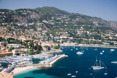
With glorious beaches and tiny coves, quaint little towns and mighty castles, this area has long been a destination of choice. This delightful fishing port offers relaxation, riverside walks and views galore.
Itinerary
Day 1 Departure
A morning departure to Dover and our ferry crossing to Calais. We then continue through France to our overnight hotel in Honfleur.

Day 2 Travel to Fouesnant Morning optional walking tour of Honfleur
This morning we spend some free time in the town or you may like to join an optional walking tour of the Old Town. This afternoon we travel the short distance to Dinan with free time, before continuing to our chosen hotel.

Days 3-5 At leisure
At leisure with time for relaxing and unwinding with two included and one optional excursion.

Included Excursion
Full Day Concarneau and Pont Aven A full day included excursion firstly visiting the fishing ports of Concarneau and Pont Aven. The view of the medieval walled town is one of the most photographed sights in Brittany. We then continue onto Pont Aven, a small town known for its mills, port and the artist Paul Gauguin. Our last visit of the day is to Quimper, the ancient capital of La Cornouaille, Brittany’s most traditional region, and has a distinctive Breton character. Shops and flags celebrating the region’s Celtic heritage can be found throughout the city. The town has a rustic atmosphere with footbridges spanning the rivers that flow through it.

Included Excursion
Full Day CLocronan, Douarnenez and Pointe du Raz A full day included excursion visiting Locronan, Douarnenez, and the Pointe du Raz. We first visit Locronan, one of the most beautiful villages in France, before continuing onto Douarnenez, which lies at the mouth of the Pouldavid Estuary. This afternoon we continue onto the Pointe du Raz, France’s equivalent to England’s Land’s End. You will have time here to explore the area, visit the Heritage Centre and look across to spectacular views.

Optional Excursion
Full Day Vannes A full day optional excursion to Vannes with the opportunity of a Gulf Cruise. Firstly calling at Auray, before continuing onto Vannes. After lunch you can relax on a 2 hour boat cruise around the Gulf of Morbihan to complete your day. The Gulf of Morbihan is a natural harbour on the coast of the département of Morbihan in the south of Brittany.

Day 6 Travel to overnight hotel
Today we begin our homeward journey travelling through the Calvados region to the picturesque medieval settlement of Mont St Michel. After our visit here we travel to our last night stop in the Paris area. Your Tour Manager / Driver may offer an optional farewell Dinner and tour in Paris.

(Please note there may be circumstances when the overnight hotel will not be in Paris, in which case the tour cannot be offered).

Last Day Travel home
We depart for Calais and our ferry crossing to Dover, arriving home during the evening.
Venue Information
Hotel Mona Lisa Cap Coz, Fouesnant
Our hotel is located on the seafront in Fouesnant, a small seaside resort of the South Finistere, between Benodet and Concarneau. The hotel facilities include a restaurant overlooking the sea, bar and lift. All bedrooms are en-suite and have a TV and a telephone.
Picture: Click to ViewPicture: Click to ViewPicture: Click to ViewPicture: Click to View
Pick-Up Points
.Ashford OBrians Public House Map
.Attleborough Outside HSBC Bank Map
.Baldock Xtra Services Map
.Barking Longbridge Road Bus Stop Map
.Basildon Coach Stop Outside Trafford House Map
.Basingstoke Bus Stop B Outsidethe Malls Shopping Centre Map
.Beckenham Bus Stop Opposite Wimpy Map
.Beddington Broadway Bus Stop Opposit Plough Public House Map
.Bexhill On Sea Town Hall Square Bus Layby Map
.Bexleyheath Central Library Map
.Biggleswade Bus Station Map
.Billericay Bus Stop Map
.Birchanger M11 Services Coach Park Map
.Bishops Stortford Station Approach Map
.Bitterne Bullar Gyratory Bus Stop Map
.Blythburgh A12 White Hart Public House Map
.Bournemouth Yellow Buses Bus Stand 6 Map
.Braintee Bus Stop Outside Tesco Map
.Brentwood Bus Stop Near KFC Map
.Brighton St Peters Church Bus Stop Map
.Bromley Bromley North Railway Station Map
.Buckhurst Hill Outside Premier Inn Map
.Bury St Edmunds Bus Stop Outside Tesco Map
.Cambridge Bus Stop Outside Railway Station Map
.Canterbury Outside Canterbury East Railway Station Map
.Carshalton Bus Stop Near Post Office Map
.Chatham Outside Holiday Inn Map
.Cheam Bus Stop A Map
.Chelmsford Army & Navy Layby Map
.Chelmsford Coach Bay Map
.Cheshunt Turners Hill (B176) Map
.Christchurch Bus Stop Opposite Sommerfields Map
.Clacton On Sea Crusader Business Park Map
.Clacton-on-Sea Outside Railway Station Map
.Colchester Outside Gala Bingo Map
.Crawley Bus Station, Stand E Map
.Crayford Opposite Town Hall Map
.Crays Hill Shepard & Dog Public House Map
.Crowborough Jades Palace Restaurant Map
.Croyden Nestle Tower Bus Stop KC Park Park Lane Map
.Dagenham Outside Morrisons Map
.Dartford Civic Centre Bus Stops Map
.Dickleburgh Chenery Garage Map
.Diss Bus Station Map
.Dover Dover Passenger Terminal Map
.Dovercourt Bus Stop Map
.Dovercourt Railway Station Map
.Dovercourt The Devon Public House Map
.Duxford Bus Stop Imperial War Museum Map
.Eastbourne Outside Pier Entrance Map
.Eltham Rail Station Bus Terminus Map
.Enfield Town Southbury Road Bus Stop Map
.Enfield Outside U G C Cinema Map
.Ewell Bus Stop Opposite Bourne Hall Map
.Fareham Bus Station Map
.Felixstowe Hamilton Road Bus Stop Map
.Ferndown Lay By Ringwood Road A348 Bus Stop Map
.Folkestone Bus Stop Outside BP Garage Map
.Fourwent Ways Burger King Map
.Frinton On Sea Bus Stop Adjacent To Railway Station Map
.Gants Hill Outside Network Q Map
.Gillingham Medway Services Map
.Gorleston The Library Map
.Gravesend Layby Outside Sainsburys Map
.Grays The Oak Public House Map
.Great Clacton Bus Stop Opposite Sommerfields Map
.Great Yarmouth Vauxhall Railway Station Map
.Hadleigh Hadleigh Church Bus Stop Map
.Halisham Bus Layby Map
.Halstead Bus Stop Stead & Simpsons Map
.Harlow Bus Station, Near Taxi Rank Map
.Hastings Bus Layby Map
.Hastings Summerfield Sports Centre Map
.Hatfield Galleria Centre Main Entrance Bus Stop Map
.Havant The Bus Station Map
.Hemel Hempstead Outside Bus Station Map
.Hoddesdon Clock Tower Map
.Holland On Sea The Roaring Donkey Map
.Hornchurch North Street Queens Theatre Bus Stop Map
.Hove Bus Stop Outside Town Hall Map
.Huntingdon Opposite BMW Garage Map
.Ilford Bus Stop Outside Stagecoach Office Map
.Ipswich Railway Station Map
.Kelvedon Railway Tavern Bus Stop Map
.Kessingland Post Office Map
.Kings Langley Outside GPO Sorting Office Map
.Kingston Bus Stop B4 Map
.Kirby Cross Bus Stop Opposite Railway Station Map
.Lawford & Manningtree Bus Shelter In Long Road Map
.Leigh On Sea Outside The Elms Public House Map
.Leigh Bus Stop Map
.Leytonstone Green Man Bus Stop Map
.Long Melford Bus Stop Opposite Cock & Bell Public House Map
.Long Stratton Budgens, By Head Stone Garage Map
.Loughton Trapps Hill Bus Stop Map
.Lowestoft Bus Stop Outside Railway Station Map
.M3 Fleet Coach Park Map
.Maidstone Bus Stop Map
.Marks Tey Bus Stop Opposite The Food Factory Map
.Mildenhall Barton Mills A11 Little Chef Travel Lodge Map
.New Eltham Bus Stop Opp Railway Station Map
.Newmarket Bus Stop Palmers Map
.Newton Flotman Bus Shelters Map
.Norwich Bus Layby John Lewis Map
.Norwich Holiday Inn Map
.Old Bexley Outside Almshouses Map
.Pakefield Tramway Hotel Map
.Pease Pottage M23 Services Map
.Pevensey Bay HSBC Bank Map
.Pitsea Gala Bingo Club Map
.Polegate Bus Stop Outside St George Church Map
.Ponders End Tescos Map
.Poole Railway Station Coach Bays Map
.Portchester A27 West Street Map
.Portsmouth The Hard Bus Station Map
.Potters Bar Bus Stop Junction Of Southgate Road Map
.Rayleigh Outside Railway Station Map
.Redbridge Outside Tube Station Map
.Redhill Bus Station Map
.Reigate Bus Stop Map
.Ringwood Meeting House Lane Map
.Rochester Outside Holiday Inn Map
.Romford Bus Stop H Map
.Sandy Kings Arms PH Map
.Sawbridgeworth White Lion Public House Map
.Sevenoaks Bus Terminus, Entrance Off High Street Map
.Shoeburyness Bus Stop Inside Asda Map
.Shoreham Going Places Map
.Sidcup Police Station Bus Stop Map
.South Benfleet New Bus Stop Map
.South Green Burstead Plough Map
.Southampton Rownhams Services M27 Map
.Southchurch Outside White Horse Map
.Southend Victoria Circus Bus Stop Map
.St Albans Bus Stop Outside DM Jewellers Map
.Stevenage Arts & Leisure Centre Map
.Sudbury Bus Station Map
.Sutton Bus Stop L Opposite Police Station Map
.Thetford Minstergate Bus Station Map
.Thorpe Bay Railway Station Map
.Thundersley Victoria House Corner Map
.Thurrock Moto Services Coach Park Map
.Tolworth Bus Stop F, Outside Marks & Map
.Tonbridge Bus Layby Map
.Trumpington Anstey Way Bus Stop Map
.Tunbridge Wells Bus Stop B Near Railway Station Map
.Uckfield Bus Station Map
.Upminster Bus Stop A Opp. Railway Station Map
.Waltham Cross Hertford Road Bus Stop Map
.Walthamstow Bus Stop Opposite Hospital Map
.Ware Old Town Hall Map
.Watford Watford Railway Station Map
.Westcliff Palace Theatre Map
.Wickford Halls Corner Map
.Winchester Bull Drove Bar End Road Map
.Witham Lloyds The Chemist Map
.Woodbridge/Martlesham Bus Stop Outside Tesco Map
.Woodford Green Bus Stop Opposite Castle Public House Map
.Woodford Waterworks Corner Bus Stop Map
.Worthing Outside Central Railway Station Map
.Wrentham A12 Village Bus Stop Map
.Wymondham Bus Stop Map
.Yoxford National Express Stop Map
Click the compass icons to preview pickups.
↑ Return to Top - Contact Us - F.A.Q. - Coach Operators - Group Bookings - Hotels - Attractions - Sitemap - Home