
Bookings for this holiday are now closed
You are here: Home » Coastal Breaks » Llandudno & Snowdonia
Llandudno & Snowdonia
| Destination: Llandudno | Operator: Crusader Holidays Terms |
| Departs: 22/10/2010 | Type: Coastal Breaks |
| Duration: 4 days | Quality: Good * * * |
| Departs Via: South East | Board: Half Board |
| Tour Code: D6473 | Transport: Coach Pickup |
Adults £215.00
Deposit Per Person Payment required in full
* Children: Not allowed
* Babies: Not allowed
Sorry, there's not enough time left to book you on this trip!
Deposit Per Person Payment required in full
* Children: Not allowed
* Babies: Not allowed
Sorry, there's not enough time left to book you on this trip!
Description
A holiday location that has something for everyone. The majestic mountains combined with the resort’s superb beaches and seaside attractions guarantee that there will never be a dull moment.Itinerary
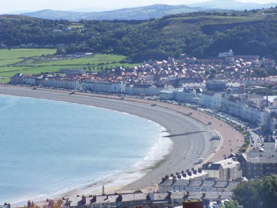
Day 1 DepartureA morning departure, stopping for lunch and refreshments en-route to our chosen hotel. Llandudno is Wales’s largest resort, uniquely situated between the hilly promontories of the Great and Little Orme with two wonderful beaches, the award-winning North Shore and the quiet, sand-duned West Shore. Llandudno has kept its Victorian and Edwardian elegance and splendour, as well as inviting many modern attractions.
Days 2-3 (4 day holidays) At leisure
Days 2–4 (5 day holidays) At leisure
Days 2–6 (7 day holidays) At leisure
At leisure with two included excursions for 4 and 5 day holidays, and three included excursions on 7 day holidays.
Included Excursion
Full Day Snowdonia area A full day included excursion to the Snowdonia area. Travelling via the Vale of Conwy, we make our way to Betws-y-Coed and the Swallow Falls before continuing via the Llanberis Pass to Llanberis and the Padarn Country Park.
Included Excursion
Half Day Conwy, Isle of Anglesey & Beaumaris A half day included excursion along the North Wales coast, firstly visiting Conwy, a delightful small town with a picturesque quayside overlooked by the mighty Conwy Castle. We continue to the Isle of Anglesey and Beaumaris before visiting Llanfairpwllgwyngyllgogerychwyrndrobwllllantysiliogogogoch. Go on, see if you can pronounce it!
Included Excursion
Full Day (ELS 7 day holidays only) Llechwedd Join us on a full day included excursion, taking a different view of the Vale of Conwy, to Llechwedd Slate Mine (admission not included). We then travel to the resort of Porthmadog before returning via Beddgellert.
Last Day Travel home
We depart for home, arriving during the evening.
In addition to the above itinerary the hotel celebrates themed weekends as follows:
12th Feb & 12th Mar Home Nations Celebration St Patricks Day, St Davids Day, St Georges Day, St Andrews Day
Celebrate our nations favourite days, all in one super holiday. Festivities include themed menus, themed hotel décor & staff costumes and themed entertainment. There will be fancy dress competitions & discounted drinks at the bar.
22nd Oct
Welsh House Party
05th Nov
Christmas Party
Venue Information
Evans Hotel, Llandudno We stay at the Evans Hotel, which is family run in a good location. The hotel facilities include bar, restaurant, games room. Bedrooms have TV and tea & coffee making facilities. The Evans hotel is famous for its various themed nights, whether it be the Welsh House Party, Turkey and Tinsel breaks or the Home Nations Party and you have the opportunity of being present.
Pick-Up Points

Click the compass icons to preview pickups.

↑ Return to Top - Contact Us - F.A.Q. - Coach Operators - Group Bookings - Hotels - Attractions - Sitemap - Home
© CoachBookings.com 2026 - Company no. 5808080 - Privacy Policy - GDPR Compliance - Terms & Conditions
CoachBookings.com, 17 Birley Street, Blackpool, FY1 1EG, United Kingdom. 0345 33 11 080
CoachBookings.com, 17 Birley Street, Blackpool, FY1 1EG, United Kingdom. 0345 33 11 080