0345 33 11 080
CoachBookings Logo
Bookings for this holiday are now closed
You are here: Home » Sight Seeing » Northumbria & Beamish

Northumbria & Beamish

Destination: NorthumbriaOperator: Crusader Holidays Terms
Departs: 10/10/2010Type: Sight Seeing
Duration: 5 daysQuality: Good * * *
Departs Via: South EastBoard: Half Board
Tour Code: D6320Transport: Coach Pickup
Supplements
Single Room £30.00 per person
Adults £339.00
Deposit Per Person Payment required in full
* Children: Not allowed
* Babies: Not allowed
Sorry! This trip has sold out.
Description
Set on the border of Scotland, it boasts over a 100 beautiful miles of Heritage Coast. As well as the perennial favourite, Beamish Museum, there is an opportunity of visiting the historic Hartlepool Quay.
Itinerary
Day 1 Departure
A morning departure stopping for lunch and refreshments en-route to our resort hotel.

Days 2-4 (5 day holidays)
At leisure with two included excursions.

Days 2-6 (7 day holidays) At leisure with four included excursions.

Included Excursion
Full Day Beamish Museum An excursion to Beamish Museum - admission included. Visit Beamish and experience the past through its people. Enjoy all of the unique attractions at Beamish in The Town, Colliery Village and Home Farm, all set in 1913. Step further back in time to the Georgian north to explore Pockerley Manor and take a ride on the 1825 Railway. Hop on board one of the Beamish trams to start your journey back in time. Put on a hard hat and go underground at a real drift mine to see how coal miners worked. Find out what school was like all those years ago and practise your handwriting on a slate. Don’t forget to visit the Jubilee Sweet Shop and Sweet Factory. Watch a demonstration of sweet making and then sample the delicious treats. Before you eat too many though, pop in to the surgery of Mr Jones, the dentist, just along the street. Step into the welcoming farmhouse kitchen at Home Farm and see traditional breeds of sheep, pigs, cattle and poultry in the farmyard and in the fields around the museum. Beamish was named as ‘2007 Visitor Attraction of the Year’ in the North East England Tourism Awards and has won ‘Best Attraction for Group Visits – Long Visit’ no fewer than five times since 2000.

Included Excursion
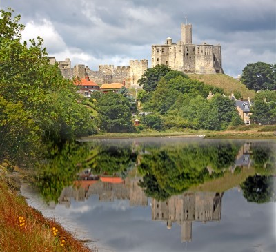
New Full Day Alnwick, Bamburgh Castle An excursion north along the coastal road exploring the unspoilt Northumbrian Coastline. Our first stop is Alnwick famous for its castle and now the garden. The castle was used as a location for the “Harry Potter” films. We continue our journey on to Bamburgh Castle with its fine views of the Farne Islands. After a brief visit of the castle, if the tides permit we cross the narrow causeway to the Holy Island which is famous for both its medieval religious heritage and also its 16th Century castle. (Please Note: Castle admissions are not included).

Included Excursion
Full Day (7 day holidays only) Hadrian’s Wall This excursion takes us to Hadrian’s Wall and Chesters Roman Fort (admission not included) before continuing to the market town of Hexham with its Abbey. Our journey also takes us across the dramatic North Pennines countryside passing the spectacular High Force waterfall.

Included Excursion
Full Day (7 day holidays only) Durham & Hartlepool An excursion to the ancient city of Durham and Hartlepool Quay. Almost encircled by the River Wear, Durham is full of architectural treasures including the castle and the Cathedral. We then travel to the coast, to Hartlepool Quay a reproduction of an 18th Century seaport. Hartlepool historic Quay is home to the Tincomalee -Europe’s oldest floating warship restored by the people of Hartlepool. In this naval yesteryear visitor attraction experience “Pressganged”, “Fighting Ships” and the Children’s maritime adventure centre.

Last Day Travel home
We depart for home, arriving during the evening.
Venue Information
Swallow Imperial Newcastle
We stay at the Swallow Imperial Newcastle where all bedrooms are en-suite with colour TV, telephone and have tea & coffee making facilities.
Picture: Click to ViewPicture: Click to ViewPicture: Click to ViewPicture: Click to View
Pick-Up Points
.Ashford The Prince Albert Roundabout Map
.Attleborough Outside HSBC Bank Map
.Barking Longbridge Road Bus Stop Map
.Basildon Coach Stop Outside Trafford House Map
.Basingstoke Bus Stop B Outsidethe Malls Shopping Centre Map
.Beckenham Bus Stop Opposite Wimpy Map
.Beddington Broadway Bus Stop Opposit Plough Public House Map
.Bexhill On Sea Town Hall Square Bus Layby Map
.Bexleyheath Central Library Map
.Billericay Bus Stop Map
.Birchanger M11 Services Coach Park Map
.Bishops Stortford Station Approach Map
.Bitterne Bullar Gyratory Bus Stop Map
.Blythburgh A12 White Hart Public House Map
.Bournemouth Yellow Buses Bus Stand 6 Map
.Braintee Bus Stop Outside Tesco Map
.Brentwood Bus Stop Near KFC Map
.Brighton St Peters Church Bus Stop Map
.Bromley Bromley North Railway Station Map
.Buckhurst Hill Outside Premier Inn Map
.Bury St Edmunds Bus Stop Outside Tesco Map
.Cambridge Bus Stop Outside Railway Station Map
.Canterbury Outside Canterbury East Railway Station Map
.Carshalton Bus Stop Near Post Office Map
.Chatham Go Outdoors Bus Stop, Adjacent To Gala Bingo Map
.Cheam Bus Stop A Map
.Chelmsford Army & Navy Layby Map
.Chelmsford Coach Bay Map
.Christchurch Bus Stop Opposite Sommerfields Map
.Clacton On Sea Crusader Business Park Map
.Clacton-on-Sea Outside Railway Station Map
.Colchester Outside Gala Bingo Map
.Crawley Bus Station, Stand E Map
.Crayford Opposite Town Hall Map
.Crays Hill Shepard & Dog Public House Map
.Crowborough Jades Palace Restaurant Map
.Croyden Nestle Tower Bus Stop KC Park Park Lane Map
.Dagenham Outside Morrisons Map
.Dartford Civic Centre Bus Stops Map
.Dickleburgh Chenery Garage Map
.Diss Bus Station Map
.Dover Dover Passenger Terminal Map
.Dovercourt Bus Stop Map
.Dovercourt Railway Station Map
.Dovercourt The Devon Public House Map
.Duxford Bus Stop Imperial War Museum Map
.Eastbourne Outside Pier Entrance Map
.Eltham Rail Station Bus Terminus Map
.Enfield Town Southbury Road Bus Stop Map
.Enfield Outside U G C Cinema Map
.Ewell Bus Stop Opposite Bourne Hall Map
.Fareham Bus Station Map
.Faversham Bus Stop Outside Sports Gnd Map
.Felixstowe Hamilton Road Bus Stop Map
.Ferndown Lay By Ringwood Road A348 Bus Stop Map
.Folkestone Bus Stop Outside BP Garage Map
.Fourwent Ways Burger King Map
.Frinton On Sea Bus Stop Adjacent To Railway Station Map
.Gants Hill Outside Network Q Map
.Gillingham Bus Stop Map
.Gorleston The Library Map
.Gravesend Layby Outside Sainsburys Map
.Grays The Oak Public House Map
.Great Clacton Bus Stop Opposite Sommerfields Map
.Great Yarmouth Vauxhall Railway Station Map
.Hadleigh Hadleigh Church Bus Stop Map
.Halisham Bus Layby Map
.Halstead Bus Stop Stead & Simpsons Map
.Harlow Bus Station, Near Taxi Rank Map
.Hastings Summerfield Sports Centre Map
.Hatfield Galleria Centre Main Entrance Bus Stop Map
.Havant The Bus Station Map
.Hemel Hempstead Outside Bus Station Map
.Holland On Sea The Roaring Donkey Map
.Hornchurch North Street Queens Theatre Bus Stop Map
.Hove Bus Stop Outside Town Hall Map
.Huntingdon Opposite BMW Garage Map
.Ilford Bus Stop Outside Stagecoach Office Map
.Ipswich Railway Station Map
.Kelvedon Railway Tavern Bus Stop Map
.Kessingland Post Office Map
.Kings Langley Outside GPO Sorting Office Map
.Kingston Bus Stop B4 Map
.Kirby Cross Bus Stop Opposite Railway Station Map
.Larkfield Bus Stop Outside The Wealden Hall Restaurant Map
.Lawford & Manningtree Bus Shelter In Long Road Map
.Leigh On Sea Outside The Elms Public House Map
.Leigh Bus Stop Map
.Leytonstone Green Man Bus Stop Map
.Long Melford Bus Stop Opposite Cock & Bell Public House Map
.Long Stratton Budgens, By Head Stone Garage Map
.Loughton Trapps Hill Bus Stop Map
.Lowestoft Bus Stop Outside Railway Station Map
.M3 Fleet Coach Park Map
.Margate Bus Stop Map
.Marks Tey Bus Stop Opposite The Food Factory Map
.Mildenhall Barton Mills A11 Little Chef Travel Lodge Map
.New Eltham Bus Stop Opp Railway Station Map
.Newmarket Bus Stop Palmers Map
.Newton Flotman Bus Shelters Map
.Norwich Bus Layby John Lewis Map
.Norwich Holiday Inn Map
.Old Bexley Outside Almshouses Map
.Pakefield Tramway Hotel Map
.Pease Pottage M23 Services Map
.Pevensey Bay HSBC Bank Map
.Pitsea Gala Bingo Club Map
.Polegate Bus Stop Outside St George Church Map
.Ponders End Tescos Map
.Poole Railway Station Coach Bays Map
.Portchester A27 West Street Map
.Portsmouth The Hard Bus Station Map
.Potters Bar Bus Stop Junction Of Southgate Road Map
.Rainham Outside Cricketers PH Map
.Ramsgate Railway Station Map
.Rayleigh Outside Railway Station Map
.Redbridge Outside Tube Station Map
.Redhill Bus Station Map
.Reigate Bus Stop Map
.Ringwood Meeting House Lane Map
.Rochester Bus Lay By Near Dickens Centre Map
.Romford Bus Stop H Map
.Sawbridgeworth White Lion Public House Map
.Sevenoaks Bus Terminus, Entrance Off High Street Map
.Shoeburyness Bus Stop Inside Asda Map
.Shoreham Going Places Map
.Sidcup Police Station Bus Stop Map
.Sittingbourne Railway Station Map
.South Benfleet New Bus Stop Map
.South Green Burstead Plough Map
.South Mimms M25/A1M Services Coach Park Map
.Southampton Rownhams Services M27 Map
.Southchurch Outside White Horse Map
.Southend Victoria Circus Bus Stop Map
.St Albans Bus Stop Outside DM Jewellers Map
.Strood Bus Stop Map
.Sudbury Bus Station Map
.Sutton Bus Stop L Opposite Police Station Map
.Thetford Minstergate Bus Station Map
.Thorpe Bay Railway Station Map
.Thundersley Victoria House Corner Map
.Thurrock Moto Services Coach Park Map
.Tolworth Bus Stop F, Outside Marks & Map
.Tonbridge Bus Layby Map
.Trumpington Anstey Way Bus Stop Map
.Tunbridge Wells Bus Stop B Near Railway Station Map
.Uckfield Bus Station Map
.Upminster Bus Stop A Opp. Railway Station Map
.Waltham Cross Hertford Road Bus Stop Map
.Walthamstow Bus Stop Opposite Hospital Map
.Watford Watford Railway Station Map
.Westcliff Palace Theatre Map
.Whitstable Oxford Bingo Club Map
.Wickford Halls Corner Map
.Winchester Bull Drove Bar End Road Map
.Witham Lloyds The Chemist Map
.Woodbridge/Martlesham Bus Stop Outside Tesco Map
.Woodford Green Bus Stop Opposite Castle Public House Map
.Woodford Waterworks Corner Bus Stop Map
.Worthing Outside Central Railway Station Map
.Wrentham A12 Village Bus Stop Map
.Wymondham Bus Stop Map
.Yoxford National Express Stop Map
Click the compass icons to preview pickups.
↑ Return to Top - Contact Us - F.A.Q. - Coach Operators - Group Bookings - Hotels - Attractions - Sitemap - Home